1980s Maps of Dinkey Creek, California
Explore 2 historic maps of Dinkey Creek from the 1980s. These maps offer a rare glimpse into what life looked like during the 1980s — showing old roads, neighborhoods, homes, and landmarks that have changed or disappeared over time.
Whether you're researching your family's past, planning a metal detecting trip, or studying how Dinkey Creek's landscape evolved across the 1980s, these high-resolution maps are a powerful tool for exploring the history of this region.
- Focus on a specific era: All maps on this page are from the 1980s, giving you a focused view of this time period.
- See what’s changed: Compare century-old streets, trails, and buildings to today's modern landscape using overlays and satellite layers.
- Research with precision: Use these maps for genealogy, historical research, land use analysis, or educational projects.
- View, download, or print: Maps are fully viewable online in high resolution, and can be downloaded or printed for your own records.
Start exploring Dinkey Creek's history through authentic maps from the 1980s. This is your window into the past.
Dinkey Creek, CA maps
(2)- 1980 Map of Shaver Lake
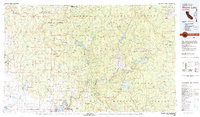 1980 Shaver Lake1980 Print · USGSThe Sierra Nevada foothills and high country come into focus during the early eighties, showing the region's complex water and timber infrastructure. Researchers can trace the heritage of local industry at Knowles Quarry, Buchanan Mine, and the hydroelectric works around Big Creek.3 unique versions available
 - 1982 Map of Dinkey Creek, 1983 Print
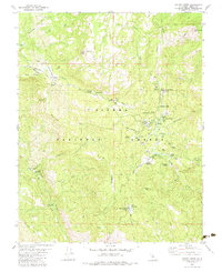 1982 Dinkey Creek1983 Print · USGSDinkey Creek and the high Sierra timberlands appear here during the early 1980s, captured as a landscape of mountain camps and forestry. Researchers can trace the footprints of Bretz Mill (Site), locate Camp El-O-Win, and find the Shaver Lookout Tower on Bald Mountain.3 unique versions available
End of results
Showing maps 1-2 of 2
Frequently asked questions
- What are the different types of historical maps available for Dinkey Creek?
- What is the oldest map of Dinkey Creek?
- Where can I purchase historical maps of Dinkey Creek for my home or office?
- Where can I download high-res historical maps of Dinkey Creek?
- Are there historical topographic maps available for Dinkey Creek?
- Is there historical aerial imagery available for Dinkey Creek?
- Where are historical maps of Dinkey Creek sourced from?