1980s Maps of Salton City, California
Explore 2 historic maps of Salton City from the 1980s. These maps offer a rare glimpse into what life looked like during the 1980s — showing old roads, neighborhoods, homes, and landmarks that have changed or disappeared over time.
Whether you're researching your family's past, planning a metal detecting trip, or studying how Salton City's landscape evolved across the 1980s, these high-resolution maps are a powerful tool for exploring the history of this region.
- Focus on a specific era: All maps on this page are from the 1980s, giving you a focused view of this time period.
- See what’s changed: Compare century-old streets, trails, and buildings to today's modern landscape using overlays and satellite layers.
- Research with precision: Use these maps for genealogy, historical research, land use analysis, or educational projects.
- View, download, or print: Maps are fully viewable online in high resolution, and can be downloaded or printed for your own records.
Start exploring Salton City's history through authentic maps from the 1980s. This is your window into the past.
Salton City, CA maps
(2)- 1982 Map of Borrego Valley, 1983 Print
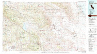 1982 Borrego Valley1983 Print · USGSThe high desert and coastal mountains of San Diego County come together in the early eighties. Researchers can trace the boundaries of the Los Coyotes Indian Reservation or locate the Desert Queen Mine and Palomar Observatory.2 unique versions available
 - 1985 Map of Salton Sea
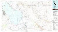 1985 Salton Sea1985 Print · USGSIn the mid-1980s, the California desert around the Salton Sea shows a unique mix of military gunnery ranges, irrigated agriculture, and shoreline settlements. Trace the Southern Pacific rail route through Niland and Bombay Beach, or locate remote desert sites like the Black Eagle Mine.2 unique versions available
End of results
Showing maps 1-2 of 2
Top cities near Salton City
Frequently asked questions
- What are the different types of historical maps available for Salton City?
- What is the oldest map of Salton City?
- Where can I purchase historical maps of Salton City for my home or office?
- Where can I download high-res historical maps of Salton City?
- Are there historical topographic maps available for Salton City?
- Is there historical aerial imagery available for Salton City?
- Where are historical maps of Salton City sourced from?