1982 Map of Borrego Valley
USGS Topo · Published 1983About this map
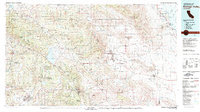
Anza-Borrego Desert State Park dominates the eastern expanse of this 1982 map, revealing the intricate geography of the Borrego Valley and Borrego Badlands before modern development intensified. The map captures a complex cultural landscape of indigenous lands, including the Los Coyotes Indian Reservation, Mesa Grande Indian Reservation, and Santa Ysabel Indian Reservation.
Find a feature on this map
76 named features on this map. Tap any name to fly to it.
Don’t see what you’re looking for? This feature index may not catch every label — zoom into the map to look around manually.
Map Details
Editions of this 1982 Borrego Valley Map
2 editions found

Other maps of this area

1893 · El Cajon
USGS Topo · 1:62,500

1893 · Escondido
USGS Topo · 1:62,500

1901 · Southern California Sheet No. 1
USGS Topo · 1:250,000

1901 · Elcajon
USGS Topo · 1:62,500

1901 · San Jacinto
USGS Topo · 1:125,000

1901 · Elsinore
USGS Topo · 1:125,000

1901 · Escondido
USGS Topo · 1:62,500

1901 · San Luis Rey
USGS Topo · 1:125,000

1903 · Cuyamaca
USGS Topo · 1:125,000

1903 · La Jolla
USGS Topo · 1:62,500