1980s Maps of Charleston View, California
Explore 8 historic maps of Charleston View from the 1980s. These maps offer a rare glimpse into what life looked like during the 1980s — showing old roads, neighborhoods, homes, and landmarks that have changed or disappeared over time.
Whether you're researching your family's past, planning a metal detecting trip, or studying how Charleston View's landscape evolved across the 1980s, these high-resolution maps are a powerful tool for exploring the history of this region.
- Focus on a specific era: All maps on this page are from the 1980s, giving you a focused view of this time period.
- See what’s changed: Compare century-old streets, trails, and buildings to today's modern landscape using overlays and satellite layers.
- Research with precision: Use these maps for genealogy, historical research, land use analysis, or educational projects.
- View, download, or print: Maps are fully viewable online in high resolution, and can be downloaded or printed for your own records.
Start exploring Charleston View's history through authentic maps from the 1980s. This is your window into the past.
Charleston View, CA maps
(8)- 1983 Map of North of Tecopa Pass
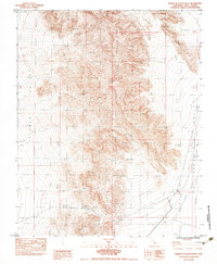 1983 North of Tecopa Pass1983 Print · USGSInyo County, California, is captured in the early 1980s as a high-desert landscape focused on the steep ridges of the Nopah Range. Researchers can trace old travel routes through Emigrant Pass and locate critical desert water sources like Horse Thief Springs and Resting Spring.
 - 1984 Map of Mound Spring
 1984 Mound Spring1984 Print · USGSPahrump Valley at the Nevada-California border was a landscape of remote ranch roads and historic boundaries in the early eighties. Researchers can trace the diagonal Von Schmidt Line (1873) and locate isolated water sources like Mound Spring.
 - 1984 Map of Nopah Peak
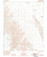 1984 Nopah Peak1984 Print · USGSInyo County's high desert peaks and the Nevada state line meet here in the mid-1980s. Trace the historical Von Schmidt Line (1873) as it cuts through the Pahrump Valley near Nopah Peak.
 - 1984 Map of Stump Spring, 1985 Print
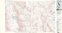
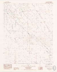 1984 Stump Spring1985 Print · USGSThe high desert border of Nevada and California comes into focus in the mid-1980s, documenting a landscape of historic transit and early surveys. Genealogists and researchers can trace the 19th-century Von Schmidt Boundary (1873) and the path of the Spanish Trail near Stump Spring (Dry).2 unique versions available
 - 1984 Map of Calvada Springs, 1985 Print
 1984 Calvada Springs1985 Print · USGSThe high-desert borderlands of Inyo and Clark counties are captured here in the mid-1980s as modern growth met historic trails. Trace the legacy of the Von Schmidt Boundary (1873) and find early infrastructure at Calvada Springs or along the Old Spanish Trail Highway.
 - 1985 Map of Mesquite Lake
 1985 Mesquite Lake1985 Print · USGSThe high desert along the Nevada-California line is captured here in the mid-1980s, showcasing a landscape defined by historic mining and transit. Researchers can trace numerous old claims like the Potosi Mine and Yellow Pine Mine or follow the historic Old Spanish Trail.2 unique versions available
 - 1986 Map of Las Vegas
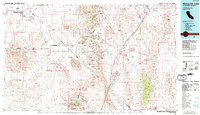
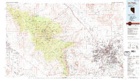 1986 Las Vegas1986 Print · USGSThe Mojave Desert landscape around mid-1980s Las Vegas reveals a city in transition, surrounded by vast federal preserves and the high peaks of the Spring Mountains. Trace the development of Henderson and Arden, or locate remote landmarks like Gagnier Station and the Calico Hills.4 unique versions available
 - 1986 Map of Death Valley Junction
 1986 Death Valley Junction1986 Print · USGSThe California-Nevada borderlands appear here in the mid-eighties, centered on the dramatic terrain of the Death Valley National Monument. Researchers can trace the path of the Tonopah and Tidewater Railroad (Abandoned) and locate remote outposts like Ryan and Bennetts Well.2 unique versions available
End of results
Showing maps 1-8 of 8
Top neighborhoods of Charleston View
Frequently asked questions
- What are the different types of historical maps available for Charleston View?
- What is the oldest map of Charleston View?
- Where can I purchase historical maps of Charleston View for my home or office?
- Where can I download high-res historical maps of Charleston View?
- Are there historical topographic maps available for Charleston View?
- Is there historical aerial imagery available for Charleston View?
- Where are historical maps of Charleston View sourced from?