1930s Maps of Alameda, California
Explore 2 historic maps of Alameda from the 1930s. These maps offer a rare glimpse into what life looked like during the 1930s — showing old roads, neighborhoods, homes, and landmarks that have changed or disappeared over time.
Whether you're researching your family's past, planning a metal detecting trip, or studying how Alameda's landscape evolved across the 1930s, these high-resolution maps are a powerful tool for exploring the history of this region.
- Focus on a specific era: All maps on this page are from the 1930s, giving you a focused view of this time period.
- See what’s changed: Compare century-old streets, trails, and buildings to today's modern landscape using overlays and satellite layers.
- Research with precision: Use these maps for genealogy, historical research, land use analysis, or educational projects.
- View, download, or print: Maps are fully viewable online in high resolution, and can be downloaded or printed for your own records.
Start exploring Alameda's history through authentic maps from the 1930s. This is your window into the past.
Alameda, CA maps
(2)- 1930 Map of Conner
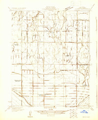 1930 Conner1930 Print · USGSKern County's agricultural basin comes into focus in the 1930s, revealing a landscape of large ranch holdings and vital irrigation works. Genealogists and historians can trace family-named landmarks like Symons Bros Ranch No 2 and the unique presence of the Ordena Migratory Sch.
 - 1933 Map of Conner
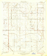 1933 Conner1933 Print · USGSKern County ranching and irrigation systems are shown in high detail during the early 1930s. Genealogists and researchers can trace family-named landmarks like Symons Ranch or locate the site of the Shafter Migratory Sch along the Kern Island Canal.2 unique versions available
End of results
Showing maps 1-2 of 2
Top cities near Alameda
- Bakersfield historical maps
- Shafter historical maps
- Arvin historical maps
- Lamont historical maps
- Weedpatch historical maps
Frequently asked questions
- What are the different types of historical maps available for Alameda?
- What is the oldest map of Alameda?
- Where can I purchase historical maps of Alameda for my home or office?
- Where can I download high-res historical maps of Alameda?
- Are there historical topographic maps available for Alameda?
- Is there historical aerial imagery available for Alameda?
- Where are historical maps of Alameda sourced from?