1930s Maps of Burhans Ranch, California
Explore 2 historic maps of Burhans Ranch from the 1930s. These maps offer a rare glimpse into what life looked like during the 1930s — showing old roads, neighborhoods, homes, and landmarks that have changed or disappeared over time.
Whether you're researching your family's past, planning a metal detecting trip, or studying how Burhans Ranch's landscape evolved across the 1930s, these high-resolution maps are a powerful tool for exploring the history of this region.
- Focus on a specific era: All maps on this page are from the 1930s, giving you a focused view of this time period.
- See what’s changed: Compare century-old streets, trails, and buildings to today's modern landscape using overlays and satellite layers.
- Research with precision: Use these maps for genealogy, historical research, land use analysis, or educational projects.
- View, download, or print: Maps are fully viewable online in high resolution, and can be downloaded or printed for your own records.
Start exploring Burhans Ranch's history through authentic maps from the 1930s. This is your window into the past.
Burhans Ranch, CA maps
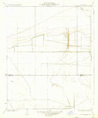
(2)- 1932 Map of Lone Tree Well
 1932 Lone Tree Well1932 Print · USGSKings and Kern Counties appear here in the early 1930s as a developing network of irrigation and land boundaries. Genealogists and historians can trace the precise county line and early infrastructure like the Homeland Canal and a remote Water Well.
 - 1936 Map of Lone Tree Well
 1936 Lone Tree Well1936 Print · USGSThe southern San Joaquin Valley comes into focus in the early 1930s, showing a landscape shaped by water engineering and early agricultural development. Researchers can trace the path of the Homeland Canal and locate the eponymous Lone Tree Well near the Kings Co Kern Co boundary line.2 unique versions available
End of results
Showing maps 1-2 of 2
Top cities near Burhans Ranch
Frequently asked questions
- What are the different types of historical maps available for Burhans Ranch?
- What is the oldest map of Burhans Ranch?
- Where can I purchase historical maps of Burhans Ranch for my home or office?
- Where can I download high-res historical maps of Burhans Ranch?
- Are there historical topographic maps available for Burhans Ranch?
- Is there historical aerial imagery available for Burhans Ranch?
- Where are historical maps of Burhans Ranch sourced from?