1940s Maps of Pine Mountain Club, California
Explore 5 historic maps of Pine Mountain Club from the 1940s. These maps offer a rare glimpse into what life looked like during the 1940s — showing old roads, neighborhoods, homes, and landmarks that have changed or disappeared over time.
Whether you're researching your family's past, planning a metal detecting trip, or studying how Pine Mountain Club's landscape evolved across the 1940s, these high-resolution maps are a powerful tool for exploring the history of this region.
- Focus on a specific era: All maps on this page are from the 1940s, giving you a focused view of this time period.
- See what’s changed: Compare century-old streets, trails, and buildings to today's modern landscape using overlays and satellite layers.
- Research with precision: Use these maps for genealogy, historical research, land use analysis, or educational projects.
- View, download, or print: Maps are fully viewable online in high resolution, and can be downloaded or printed for your own records.
Start exploring Pine Mountain Club's history through authentic maps from the 1940s. This is your window into the past.
Pine Mountain Club, CA maps
(5)- 1943 Map of Sawmill Mountain, 1959 Print
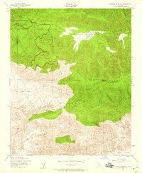 1943 Sawmill Mountain1959 Print · USGSHigh in the mountain borderlands of Ventura and Kern counties during the 1940s, this area shows a landscape of forest management and early recreation. Trace the sites of Camp Condor, the Lookout Tower on Mt Pinos, and the Ski Run near Cerro Noroeste.4 unique versions available
 - 1943 Map of Cuddy Valley, 1959 Print
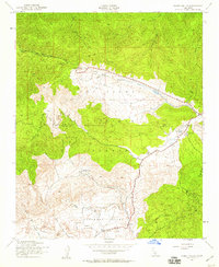 1943 Cuddy Valley1959 Print · USGSVentura and Kern counties meet in these high mountain valleys during the 1940s, showing a landscape of mining and summer camps. Researchers can locate the Stauffer post office, the Chuchupate Ranger Sta, and old workings like the Jewel Mine.6 unique versions available
 - 1944 Map of Sawmill Mountain
 1944 Sawmill Mountain1944 Print · USGSThe Ventura and Kern county line runs across these high mountain ridges during the mid-1940s. Researchers can trace early forest infrastructure from Mt Pinos Lookout to local hubs like Camp Condor and Lockwood Valley.
 - 1944 Map of Cuddy Valley
 1944 Cuddy Valley1944 Print · USGSThe rugged boundary of Ventura and Kern counties is captured here during the 1940s, highlighting a landscape of resource extraction and early mountain tourism. Researchers can locate the Frazier Borax Mine, the Mt Pinos CCC Camp, and the settlement of Stauffer.2 unique versions available
 - 1949 Map of Los Angeles
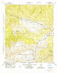
 1949 Los Angeles1949 Print · USGSSouthern California and the South Coast appear at the onset of the post-war boom, from the Channel Islands to the Mojave Desert. Trace early aviation sites like Lockheed Air Terminal and mining history at the Redrock Quicksilver Mine and Redrover Mine.2 unique versions available
End of results
Showing maps 1-5 of 5
Frequently asked questions
- What are the different types of historical maps available for Pine Mountain Club?
- What is the oldest map of Pine Mountain Club?
- Where can I purchase historical maps of Pine Mountain Club for my home or office?
- Where can I download high-res historical maps of Pine Mountain Club?
- Are there historical topographic maps available for Pine Mountain Club?
- Is there historical aerial imagery available for Pine Mountain Club?
- Where are historical maps of Pine Mountain Club sourced from?