1940s Maps of Wherry Housing, California
Explore 2 historic maps of Wherry Housing from the 1940s. These maps offer a rare glimpse into what life looked like during the 1940s — showing old roads, neighborhoods, homes, and landmarks that have changed or disappeared over time.
Whether you're researching your family's past, planning a metal detecting trip, or studying how Wherry Housing's landscape evolved across the 1940s, these high-resolution maps are a powerful tool for exploring the history of this region.
- Focus on a specific era: All maps on this page are from the 1940s, giving you a focused view of this time period.
- See what’s changed: Compare century-old streets, trails, and buildings to today's modern landscape using overlays and satellite layers.
- Research with precision: Use these maps for genealogy, historical research, land use analysis, or educational projects.
- View, download, or print: Maps are fully viewable online in high resolution, and can be downloaded or printed for your own records.
Start exploring Wherry Housing's history through authentic maps from the 1940s. This is your window into the past.
Wherry Housing, CA maps
(2)- 1942 Map of Rogers Lake
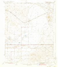 1942 Rogers Lake1942 Print · USGSThe Antelope Valley and Mojave Desert appear in the early 1940s as a landscape of remote ranches and emerging military ranges. Trace the early boundaries of the Muroc Bombing and Gunnery Range and find rural landmarks like Redman Sch and Solon.2 unique versions available
 - 1947 Map of Fluhr
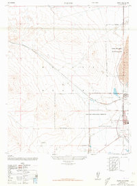 1947 Fluhr1947 Print · USGSThe high desert of Kern County was undergoing a military transformation in the late 1940s as aviation testing expanded. Researchers can trace the early layout of Muroc and the Muroc Army Airfield along the edge of the vast Rogers Lake.3 unique versions available
End of results
Showing maps 1-2 of 2
Top cities near Wherry Housing
- Lancaster historical maps
- Rosamond historical maps
- California City historical maps
- Mojave historical maps
Frequently asked questions
- What are the different types of historical maps available for Wherry Housing?
- What is the oldest map of Wherry Housing?
- Where can I purchase historical maps of Wherry Housing for my home or office?
- Where can I download high-res historical maps of Wherry Housing?
- Are there historical topographic maps available for Wherry Housing?
- Is there historical aerial imagery available for Wherry Housing?
- Where are historical maps of Wherry Housing sourced from?