1920s Maps of Corcoran, California
Explore 2 historic maps of Corcoran from the 1920s. These maps offer a rare glimpse into what life looked like during the 1920s — showing old roads, neighborhoods, homes, and landmarks that have changed or disappeared over time.
Whether you're researching your family's past, planning a metal detecting trip, or studying how Corcoran's landscape evolved across the 1920s, these high-resolution maps are a powerful tool for exploring the history of this region.
- Focus on a specific era: All maps on this page are from the 1920s, giving you a focused view of this time period.
- See what’s changed: Compare century-old streets, trails, and buildings to today's modern landscape using overlays and satellite layers.
- Research with precision: Use these maps for genealogy, historical research, land use analysis, or educational projects.
- View, download, or print: Maps are fully viewable online in high resolution, and can be downloaded or printed for your own records.
Start exploring Corcoran's history through authentic maps from the 1920s. This is your window into the past.
Corcoran, CA maps
(2)- 1928 Map of Waukena
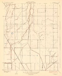 1928 Waukena1928 Print · USGSThe agricultural landscape of the southern Central Valley is revealed in the mid-twenties, centered on the settlement of Waukena. Researchers can trace the early irrigation network and rural infrastructure including the Lakeside School, Aurora School, and the Sweet Canal.2 unique versions available
 - 1928 Map of Corcoran
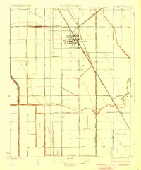 1928 Corcoran1928 Print · USGSThe San Joaquin Valley's agricultural transformation is on full display here during the late 1920s as irrigation projects reshaped the land. Trace the early growth of Corcoran and vanished points like Turnbull alongside rural landmarks like Riverdale School and the Tule River.3 unique versions available
End of results
Showing maps 1-2 of 2
Top cities near Corcoran
- Visalia historical maps
- Tulare historical maps
- Hanford historical maps
- Lemoore historical maps
- Home Garden historical maps
- Waukena historical maps
Frequently asked questions
- What are the different types of historical maps available for Corcoran?
- What is the oldest map of Corcoran?
- Where can I purchase historical maps of Corcoran for my home or office?
- Where can I download high-res historical maps of Corcoran?
- Are there historical topographic maps available for Corcoran?
- Is there historical aerial imagery available for Corcoran?
- Where are historical maps of Corcoran sourced from?