
1928 Map of Waukena
USGS Topo · Published 1928About this map
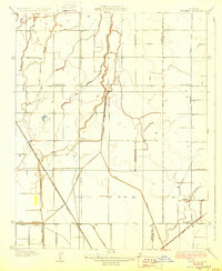
Waukena sits at the heart of this agricultural landscape, defined by a complex irrigation network of canals and ditches in the mid-1920s. The region is marked by an extensive grid of local roads and water management features like the Sweet Canal and Dallas Ditch, reflecting the era's focus on reclaiming the Central Valley floor for farming. The Atchison Topeka and Santa Fe railroad cuts a sharp diagonal through the terrain, providing a vital connection for local growers to distant markets. Social and educational life in this rural district is anchored by the Lakeside School and Aurora School, which serve the dispersed family farms. Natural watercourses like Cross Creek and Cameron Creek wind through the surveyed sections, often intersecting with man-made improvements such as Lakelands and Unit No 2.
Find a feature on this map
22 named features on this map. Tap any name to fly to it.
Don’t see what you’re looking for? This feature index may not catch every label — zoom into the map to look around manually.
Map Details
Editions of this 1928 Waukena Map
2 editions found
Other maps of this area

1926 · Goshen
USGS Topo · 1:31,680

1926 · Hanford
USGS Topo · 1:31,680

1927 · Remnoy
USGS Topo · 1:31,680

1927 · Lake View School
USGS Topo · 1:31,680

1927 · Paige
USGS Topo · 1:31,680

1928 · Corcoran
USGS Topo · 1:31,680

1929 · Guernsey
USGS Topo · 1:31,680

1932 · El Rico Ranch
USGS Topo · 1:31,680
1936 · El Rico Ranch
USGS Topo · 1:31,680
1942 · Corcoran
USGS Topo · 1:62,500