1930s Maps of Kettleman Station, California
Explore 2 historic maps of Kettleman Station from the 1930s. These maps offer a rare glimpse into what life looked like during the 1930s — showing old roads, neighborhoods, homes, and landmarks that have changed or disappeared over time.
Whether you're researching your family's past, planning a metal detecting trip, or studying how Kettleman Station's landscape evolved across the 1930s, these high-resolution maps are a powerful tool for exploring the history of this region.
- Focus on a specific era: All maps on this page are from the 1930s, giving you a focused view of this time period.
- See what’s changed: Compare century-old streets, trails, and buildings to today's modern landscape using overlays and satellite layers.
- Research with precision: Use these maps for genealogy, historical research, land use analysis, or educational projects.
- View, download, or print: Maps are fully viewable online in high resolution, and can be downloaded or printed for your own records.
Start exploring Kettleman Station's history through authentic maps from the 1930s. This is your window into the past.
Kettleman Station, CA maps
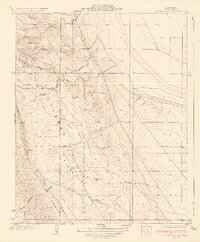
(2)- 1930 Map of Middle Dome
 1930 Middle Dome1930 Print · USGSKings County oil country comes into focus in 1930, capturing the landscape during the development of the West Side fields. Researchers can trace the early petroleum industry at the Discovery Well and follow the route of the Paso Robles Hanford Road across the Kettleman Hills.
 - 1934 Map of Los Viejos Hills
 1934 Los Viejos Hills1934 Print · USGSKings County terrain and the burgeoning infrastructure of the oil fields come into focus in this mid-1930s survey. Researchers can trace the early path of the Paso Robles Highway and locate vanished sites like Los Medanos and La Esquadilla.3 unique versions available
End of results
Showing maps 1-2 of 2
Top cities near Kettleman Station
Frequently asked questions
- What are the different types of historical maps available for Kettleman Station?
- What is the oldest map of Kettleman Station?
- Where can I purchase historical maps of Kettleman Station for my home or office?
- Where can I download high-res historical maps of Kettleman Station?
- Are there historical topographic maps available for Kettleman Station?
- Is there historical aerial imagery available for Kettleman Station?
- Where are historical maps of Kettleman Station sourced from?