Old Maps of Hobergs, California for Genealogy
Trace your family roots with 15 historic maps of Hobergs. These high-res maps reveal old neighborhoods, homesites, landmarks, and streets — helping you uncover where your ancestors lived and how the area evolved over time.
- Explore historic neighborhoods: Identify where your relatives may have lived in the 1800s or 1900s.
- Compare maps over time: Trace the changes in streets, buildings, and landmarks for multi-generational research.
- Perfect for genealogy & ancestry research: Used by family historians and researchers to map out lineage and migration.
These maps are an incredible resource for exploring your personal connection to Hobergs's past.
Hobergs, CA maps
(15)- 1945 Map of Lower Lake
 1945 Lower Lake1945 Print · USGSLake County's famous resort and mercury-mining districts are shown in high detail during the mid-1940s. Researchers can locate vanished structures at Hould Gibson Camp, trace the namesake springs at Anderson Springs, and find rural institutions like Cobb Valley Sch.2 unique versions available
 - 1947 Map of Santa Rosa
 1947 Santa Rosa1947 Print · USGSNorthern California in the late 1940s was a landscape of agricultural valleys and vital rail hubs. Trace the historic routes of the Northwestern Pacific through Healdsburg or explore the mid-century waterfronts of Vallejo and Benicia near Mare Island.
 - 1949 Map of Santa Rosa
 1949 Santa Rosa1949 Print · USGSThe North Bay and Wine Country appear here in the late 1940s, when the Northwestern Pacific RR still dominated regional transit. Genealogists and historians can trace old coastal outposts like Anchor Bay Settlement and the early layout of Santa Rosa.2 unique versions available
 - 1958 Map of Whispering Pines, 1961 Print
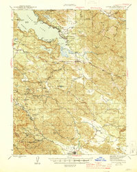
 1958 Whispering Pines1961 Print · USGSLake County at the end of the 1950s was a hub for mineral spring resorts and mountain industry. Genealogists and historians can trace the foundations of Hobergs, Anderson Springs, and Harbin Springs, or locate old operations like the Big Chief Mine.4 unique versions available
 - 1958 Map of Lower Lake, 1962 Print
 1958 Lower Lake1962 Print · USGSLake County was a burgeoning destination for mineral spring resorts and lakeside living in the late fifties. Genealogists and historians can trace the foundations of Clearlake Highlands, the winding Putah Creek, and historic sites like Hobergs and Sulphur Bank Mine.2 unique versions available
 - 1958 Map of Santa Rosa, 1968 Print
 1958 Santa Rosa1968 Print · USGSThe North Bay and Wine Country are captured in the mid-twentieth century as the region balanced its agricultural roots with a growing military and recreational footprint. Researchers can trace the Northwestern Pacific RR through the Russian River valley or locate landmarks like the Petaluma Adobe Historical Monument and The Geysers Resort.3 unique versions available
 - 1962 Map of Santa Rosa
 1962 Santa Rosa1962 Print · USGSThe North Bay and Wine Country were entering a period of significant growth in the early sixties, anchored by established rail corridors and coastal maritime commerce. Genealogists and historians can trace the development of Santa Rosa, locate the Mare Island Naval Shipyard, and follow the Northwestern Pacific RR through the Cotati Valley.
 - 1964 Map of Santa Rosa
 1964 Santa Rosa1964 Print · USGSThe North Bay and Wine Country appear in the mid-fifties during a period of significant military and educational growth. Trace old rail lines like the Northwestern Pacific RR and explore historic sites from Petaluma to the Benicia Arsenal.
 - 1972 Map of Healdsburg, 1975 Print
 1972 Healdsburg1975 Print · USGSNorthern California wine country and the lower Lake County basins appear here during the early seventies. Trace the Northwestern Pacific rail line and discover foothill communities like Middletown and Loch Lomond.2 unique versions available
 - 1993 Map of Whispering Pines
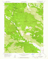
 1993 Whispering Pines1993 Print · USGSLake County resort life and geothermal energy development meet in the early nineties near the Boggs Mtn State Forest. Researchers can trace the legacy of mineral water retreats at Harbin Springs and Anderson Springs or locate numerous Geothermal Wells on the mountain ridges.
 - 1998 Map of Whispering Pines, 2002 Print
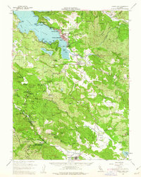
 1998 Whispering Pines2002 Print · USGSThe mountains of Lake County in the late nineties show a unique mix of geothermal energy production and mountain resorts. Researchers can trace historic retreats at Whispering Pines, locate the Power Plant near Anderson Springs, or explore Loch Lomond.
 - 2012 Map of Whispering Pines, 2012 Print
 2012 Whispering Pines2012 Print · USGSCovers Hobergs, including Cobb, Whispering Pines, and other nearby areas
 - 2015 Map of Whispering Pines, 2015 Print
 2015 Whispering Pines2015 Print · USGSCovers Hobergs, including Cobb, Whispering Pines, and other nearby areas
 - 2018 Map of Whispering Pines, 2018 Print
 2018 Whispering Pines2018 Print · USGSCovers Hobergs, including Cobb, Whispering Pines, and other nearby areas
 - 2021 Map of Whispering Pines, 2021 Print
 2021 Whispering Pines2021 Print · USGSThe Lake County highlands come into focus in the early twenty-first century, showcasing a unique cluster of mountain retreats and mineral springs. Researchers can trace the development of historic sites like Harbin Springs, Ettawa Springs, and the community of Whispering Pines along the Mayacmas ridgelines.
End of results
Showing maps 1-15 of 15
Top cities near Hobergs
- Clearlake historical maps
- Healdsburg historical maps
- Lakeport historical maps
- Clearlake Riviera historical maps
- Kelseyville historical maps
- Clearlake Oaks historical maps
See more
Frequently asked questions
- What are the different types of historical maps available for Hobergs?
- What is the oldest map of Hobergs?
- Where can I purchase historical maps of Hobergs for my home or office?
- Where can I download high-res historical maps of Hobergs?
- Are there historical topographic maps available for Hobergs?
- Is there historical aerial imagery available for Hobergs?
- Where are historical maps of Hobergs sourced from?