1990s Maps of Middletown, California
Explore 8 historic maps of Middletown from the 1990s. These maps offer a rare glimpse into what life looked like during the 1990s — showing old roads, neighborhoods, homes, and landmarks that have changed or disappeared over time.
Whether you're researching your family's past, planning a metal detecting trip, or studying how Middletown's landscape evolved across the 1990s, these high-resolution maps are a powerful tool for exploring the history of this region.
- Focus on a specific era: All maps on this page are from the 1990s, giving you a focused view of this time period.
- See what’s changed: Compare century-old streets, trails, and buildings to today's modern landscape using overlays and satellite layers.
- Research with precision: Use these maps for genealogy, historical research, land use analysis, or educational projects.
- View, download, or print: Maps are fully viewable online in high resolution, and can be downloaded or printed for your own records.
Start exploring Middletown's history through authentic maps from the 1990s. This is your window into the past.
Middletown, CA maps
(8)- 1993 Map of Mount St. Helena
 1993 Mount St. Helena1993 Print · USGSThe high ridges where Sonoma, Lake, and Napa counties meet are captured here in the early nineties, showing a landscape of geothermal energy and protected wilderness. Researchers can trace historic property lines like Knights Grant and find old mining sites including Chicago Mine and Wall Street Mine.
 - 1993 Map of Detert Reservoir
 1993 Detert Reservoir1993 Print · USGSThe mining-scarred ridges of the Mayacmas Mountains come into focus in the early 1990s as they bridge Lake and Napa counties. Genealogists and historians can trace the locations of legendary quicksilver workings like the Oat Hill Mine and Silverado Mine near Table Mountain.
 - 1993 Map of Whispering Pines
 1993 Whispering Pines1993 Print · USGSLake County resort life and geothermal energy development meet in the early nineties near the Boggs Mtn State Forest. Researchers can trace the legacy of mineral water retreats at Harbin Springs and Anderson Springs or locate numerous Geothermal Wells on the mountain ridges.
 - 1993 Map of Middletown
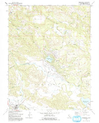 1993 Middletown1993 Print · USGSMiddletown and the surrounding ranch lands of southern Lake County are seen here in the early nineties. Genealogists and historians can trace the Cem and Historical Marker while exploring features like Hidden Valley Lake and the US Coast Guard Reservation.
 - 1997 Map of Mount Saint Helena, 1998 Print
 1997 Mount Saint Helena1998 Print · USGSThe high Mayacmas Mountains come into focus in the late nineties, showing the rugged intersection of Sonoma, Lake, and Napa counties. Researchers can trace historic mining operations at the Chicago and Helen mines or locate the Locke Cabin Site.
 - 1997 Map of Detert Reservoir, 1998 Print
 1997 Detert Reservoir1998 Print · USGSThe rugged mining districts of Lake and Napa counties come to life in this late twentieth-century survey. Trace the heritage of the region's mercury industry through sites like the Oat Hill Mine, Silverado Mine, and the historic town of Middletown.
 - 1998 Map of Middletown, 2002 Print
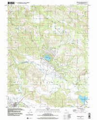 1998 Middletown2002 Print · USGSMiddletown and its surrounding valleys are captured here in the late nineties as residential growth began to encircle the area's natural springs and creek beds. Researchers can locate the local Cem, the US Coast Guard Reservation, and trace the development around Hidden Valley Lake.
 - 1998 Map of Whispering Pines, 2002 Print
 1998 Whispering Pines2002 Print · USGSThe mountains of Lake County in the late nineties show a unique mix of geothermal energy production and mountain resorts. Researchers can trace historic retreats at Whispering Pines, locate the Power Plant near Anderson Springs, or explore Loch Lomond.
End of results
Showing maps 1-8 of 8
Top cities near Middletown
- Windsor historical maps
- Clearlake historical maps
- Healdsburg historical maps
- Calistoga historical maps
- Clearlake Riviera historical maps
- Kelseyville historical maps
See more
Frequently asked questions
- What are the different types of historical maps available for Middletown?
- What is the oldest map of Middletown?
- Where can I purchase historical maps of Middletown for my home or office?
- Where can I download high-res historical maps of Middletown?
- Are there historical topographic maps available for Middletown?
- Is there historical aerial imagery available for Middletown?
- Where are historical maps of Middletown sourced from?