1950s Maps of Middletown, California
Explore 7 historic maps of Middletown from the 1950s. These maps offer a rare glimpse into what life looked like during the 1950s — showing old roads, neighborhoods, homes, and landmarks that have changed or disappeared over time.
Whether you're researching your family's past, planning a metal detecting trip, or studying how Middletown's landscape evolved across the 1950s, these high-resolution maps are a powerful tool for exploring the history of this region.
- Focus on a specific era: All maps on this page are from the 1950s, giving you a focused view of this time period.
- See what’s changed: Compare century-old streets, trails, and buildings to today's modern landscape using overlays and satellite layers.
- Research with precision: Use these maps for genealogy, historical research, land use analysis, or educational projects.
- View, download, or print: Maps are fully viewable online in high resolution, and can be downloaded or printed for your own records.
Start exploring Middletown's history through authentic maps from the 1950s. This is your window into the past.
Middletown, CA maps
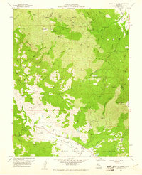
(7)- 1958 Map of Middletown, 1961 Print
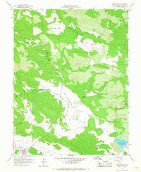 1958 Middletown1961 Print · USGSMiddletown and the surrounding Lake County valleys are shown here in the late fifties, during a period of steady ranching and early water management. Researchers can locate the Cem near the town center or trace the course of Putah Creek past the Military Reservation and McCreary Lake.3 unique versions available
 - 1958 Map of Detert Reservoir, 1961 Print
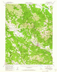
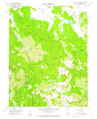 1958 Detert Reservoir1961 Print · USGSThe Mayacamas Mountains in the late fifties remained a rugged hub of mercury and silver mining. Genealogists and industrial historians can trace the foundations of the Oat Hill Mine, Corona Mine, and Silverado Mine along the winding Old Grade.5 unique versions available
 - 1958 Map of Whispering Pines, 1961 Print
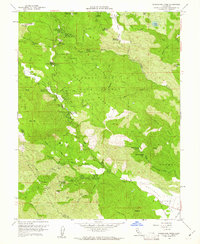 1958 Whispering Pines1961 Print · USGSLake County at the end of the 1950s was a hub for mineral spring resorts and mountain industry. Genealogists and historians can trace the foundations of Hobergs, Anderson Springs, and Harbin Springs, or locate old operations like the Big Chief Mine.4 unique versions available
 - 1958 Map of Lower Lake, 1962 Print
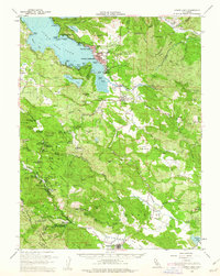 1958 Lower Lake1962 Print · USGSLake County was a burgeoning destination for mineral spring resorts and lakeside living in the late fifties. Genealogists and historians can trace the foundations of Clearlake Highlands, the winding Putah Creek, and historic sites like Hobergs and Sulphur Bank Mine.2 unique versions available
 - 1958 Map of Santa Rosa, 1968 Print
 1958 Santa Rosa1968 Print · USGSThe North Bay and Wine Country are captured in the mid-twentieth century as the region balanced its agricultural roots with a growing military and recreational footprint. Researchers can trace the Northwestern Pacific RR through the Russian River valley or locate landmarks like the Petaluma Adobe Historical Monument and The Geysers Resort.3 unique versions available
 - 1959 Map of Mount St. Helena, 1961 Print
 1959 Mount St. Helena1961 Print · USGSThe rugged Mayacmas Mountains during the late fifties reveal a landscape shaped by mining and remote ranching. Local historians can trace the legacy of quicksilver mining at the Western Mine or locate the settlement of Kellogg and the secluded Locke Cabin.3 unique versions available
 - 1959 Map of Calistoga, 1962 Print
 1959 Calistoga1962 Print · USGSThe northern Napa Valley and Mayacamas highlands are captured here in the late fifties during a period of rising viticulture and active mining. Researchers can locate historic sites like the Bale Mill Historical Monument or trace dozens of old mercury workings such as the Oat Hill Extension Mine and Mirabel Mine.2 unique versions available
End of results
Showing maps 1-7 of 7
Top cities near Middletown
- Windsor historical maps
- Clearlake historical maps
- Healdsburg historical maps
- Calistoga historical maps
- Clearlake Riviera historical maps
- Kelseyville historical maps
See more
Frequently asked questions
- What are the different types of historical maps available for Middletown?
- What is the oldest map of Middletown?
- Where can I purchase historical maps of Middletown for my home or office?
- Where can I download high-res historical maps of Middletown?
- Are there historical topographic maps available for Middletown?
- Is there historical aerial imagery available for Middletown?
- Where are historical maps of Middletown sourced from?