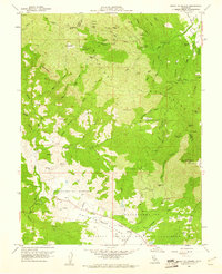
1959 Map of Mount St. Helena
USGS Topo · Published 1961About this map
Mount St Helena dominates the eastern horizon of this 1959 landscape, standing at the meeting point of Sonoma, Lake, and Napa counties. The rugged terrain of the Mayacmas Mountains is marked by a legacy of mercury and mineral extraction, evidenced by clusters of workings such as the Chicago Mine, Helen Mine, and the Western Mine. In the lower elevations to the southwest, Knights Valley provides a contrast with more accessible terrain, where the settlement of Kellogg and a local Cem are situated along the path of Maacama Creek. This survey captures a specific era of California's back-country infrastructure, including a Fish Hatchery in Tanbark Canyon and various remote outposts like Locke Cabin. The map details the complex drainage patterns of the region, from the headwaters of Big Sulphur Creek to the winding course of Redwood Creek.
Find a feature on this map
62 named features on this map. Tap any name to fly to it.
Don’t see what you’re looking for? This feature index may not catch every label — zoom into the map to look around manually.
Map Details
Editions of this 1959 Mount St. Helena Map
Other maps of this area

1920 · Healdsburg
USGS Topo · 1:62,500

1921 · Kelseyville
USGS Topo · 1:62,500

1927 · Calistoga
USGS Topo · 1:62,500

1933 · Healdsburg
USGS Topo · 1:48,000

1940 · Healdsburg
USGS Topo · 1:62,500

1943 · Calistoga
USGS Topo · 1:62,500

1943 · Kelseyville
USGS Topo · 1:62,500

1945 · Calistoga
USGS Topo · 1:62,500

1945 · Lower Lake
USGS Topo · 1:62,500

1947 · Santa Rosa
USGS Topo · 1:250,000