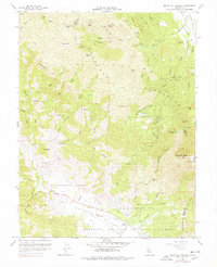
1959 Map of Mount St. Helena
USGS Topo · Published 1978About this map
Chicago Mine, Helen Mine, and the Wall Street Mine dot the northern slopes of the Mayacmas Mountains, marking a region defined by mid-century resource extraction and rugged terrain. This late 1950s record captures the remote character of the borderlands between Sonoma, Lake, and Napa Counties, where the high point of Mount St Helena dominates the landscape.
Find a feature on this map
58 named features on this map. Tap any name to fly to it.
Don’t see what you’re looking for? This feature index may not catch every label — zoom into the map to look around manually.
Map Details
Editions of this 1959 Mount St. Helena Map
Other maps of this area

1920 · Healdsburg
USGS Topo · 1:62,500

1921 · Kelseyville
USGS Topo · 1:62,500

1927 · Calistoga
USGS Topo · 1:62,500

1933 · Healdsburg
USGS Topo · 1:48,000

1940 · Healdsburg
USGS Topo · 1:62,500

1943 · Calistoga
USGS Topo · 1:62,500

1943 · Kelseyville
USGS Topo · 1:62,500

1945 · Calistoga
USGS Topo · 1:62,500

1945 · Lower Lake
USGS Topo · 1:62,500

1947 · Santa Rosa
USGS Topo · 1:250,000