1900s (20th Century) Maps of Rice Fork Summer Homes, California
Explore 7 historic maps of Rice Fork Summer Homes from the 1900s (20th Century). These maps offer a rare glimpse into what life looked like during the 1900s — showing old roads, neighborhoods, homes, and landmarks that have changed or disappeared over time.
Whether you're researching your family's past, planning a metal detecting trip, or studying how Rice Fork Summer Homes's landscape evolved across the 1900s, these high-resolution maps are a powerful tool for exploring the history of this region.
- Focus on a specific era: All maps on this page are from the 1900s, giving you a focused view of this time period.
- See what’s changed: Compare century-old streets, trails, and buildings to today's modern landscape using overlays and satellite layers.
- Research with precision: Use these maps for genealogy, historical research, land use analysis, or educational projects.
- View, download, or print: Maps are fully viewable online in high resolution, and can be downloaded or printed for your own records.
Start exploring Rice Fork Summer Homes's history through authentic maps from the 1900s. This is your window into the past.
Rice Fork Summer Homes, CA maps
(7)- 1922 Map of Hullville
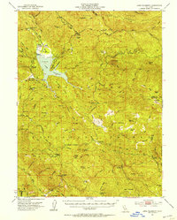
 1922 Hullville1922 Print · USGSThe pre-reservoir wilderness of Lake County is captured in this 1916 survey, shortly before the valley was flooded. Genealogists and historians can trace early homesteads and camps like Hullville, Boardman Camp, and Masons along the South Fork Eel River.
 - 1951 Map of Lake Pillsbury, 1953 Print
 1951 Lake Pillsbury1953 Print · USGSLake County and the Mendocino National Forest are captured in the early fifties as a landscape of remote ranches and timber mills. Genealogists and historians can locate legacy sites like Fuller Ranch, Prather Mill, and the Snow Mtn House.5 unique versions available
 - 1957 Map of Ukiah, 1966 Print
 1957 Ukiah1966 Print · USGSNorthern California's diverse terrain comes into focus in the mid-1950s, from the rugged timberlands of the Jackson State Forest to the productive Sacramento Valley. Genealogists and historians can trace the rail lines of the Northwestern Pacific or locate early valley settlements like Arbuckle and Paskenta.3 unique versions available
 - 1960 Map of Ukiah
 1960 Ukiah1960 Print · USGSNorthern California during the late fifties reveals a landscape of deep timber forests and valley agriculture before modern expansion. Trace the historic rail lines of the California Western RR and the Northwestern Pacific RR through settlements like Fort Bragg and Ukiah.2 unique versions available
 - 1967 Map of Lake Pillsbury, 1969 Print
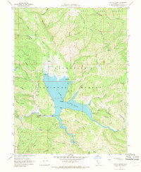 1967 Lake Pillsbury1969 Print · USGSLake County, California, is captured in the late sixties as a hub for wilderness recreation and water management within the Mendocino National Forest. Researchers can trace the development of Gravelly Valley through the Gravelly Valley Airport, Scott Dam, and remote sites like Soda Creek Station.4 unique versions available
 - 1994 Map of Lakeport
 1994 Lakeport1994 Print · USGSCoastal mountains meet the fertile Sacramento Valley in the 1990s, where the waters of Clear Lake define the western landscape. Researchers can trace the industrial footprint of the Sulphur Bank Mine, follow the Southern Pacific RR tracks, or locate old settlements like Fouts Springs and Lodoga.
 - 1996 Map of Lake Pillsbury, 2001 Print
 1996 Lake Pillsbury2001 Print · USGSLake County's high forest country is centered on the waters of the Eel River in the late nineties. Local researchers can trace the locations of family holdings and mountain retreats like Faraway Ranch, Scott Dam, and the Lake Pillsbury Resort.
End of results
Showing maps 1-7 of 7
Frequently asked questions
- What are the different types of historical maps available for Rice Fork Summer Homes?
- What is the oldest map of Rice Fork Summer Homes?
- Where can I purchase historical maps of Rice Fork Summer Homes for my home or office?
- Where can I download high-res historical maps of Rice Fork Summer Homes?
- Are there historical topographic maps available for Rice Fork Summer Homes?
- Is there historical aerial imagery available for Rice Fork Summer Homes?
- Where are historical maps of Rice Fork Summer Homes sourced from?