1900s (20th Century) Maps of Susanville, California
Explore 16 historic maps of Susanville from the 1900s (20th Century). These maps offer a rare glimpse into what life looked like during the 1900s — showing old roads, neighborhoods, homes, and landmarks that have changed or disappeared over time.
Whether you're researching your family's past, planning a metal detecting trip, or studying how Susanville's landscape evolved across the 1900s, these high-resolution maps are a powerful tool for exploring the history of this region.
- Focus on a specific era: All maps on this page are from the 1900s, giving you a focused view of this time period.
- See what’s changed: Compare century-old streets, trails, and buildings to today's modern landscape using overlays and satellite layers.
- Research with precision: Use these maps for genealogy, historical research, land use analysis, or educational projects.
- View, download, or print: Maps are fully viewable online in high resolution, and can be downloaded or printed for your own records.
Start exploring Susanville's history through authentic maps from the 1900s. This is your window into the past.
Susanville, CA maps
(16)- 1954 Map of Susanville
 1954 Susanville1954 Print · USGSMid-century Susanville and the surrounding Honey Lake Valley are captured here during a period of steady growth and rail reliance. Researchers can trace family ties at the Lassen Cem, locate Peter Lassens Grave, and see the early layout of the Susanville Indian Rancheria.3 unique versions available
 - 1954 Map of Litchfield, 1955 Print
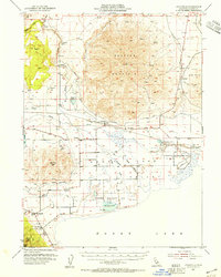 1954 Litchfield1955 Print · USGSLassen County's high desert landscape comes alive in the mid-fifties, showing the intersection of ranching and rail as the Southern Pacific spans the valley. Researchers can find old community hubs like Standish and Litchfield, alongside the remote Wendel Hot Springs and Lake School.3 unique versions available
 - 1955 Map of Westwood, 1959 Print
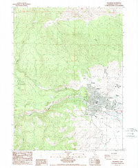
 1955 Westwood1959 Print · USGSIn the mid-fifties, the northeastern California interior supported a landscape of mountain timber and high-desert basins. Genealogists and historians can locate early settlements and industrial sites like Susanville, Herlong, and the Sierra Ordinance Depot.
 - 1958 Map of Westwood
 1958 Westwood1958 Print · USGSNorthern California in the late fifties shows a landscape of volcanic peaks and rising reservoirs. Researchers can locate the Sierra Ordinance Depot and trace mountain infrastructure through the Hat Creek Ranger Station and Stacy Siding.
 - 1959 Map of Westwood
 1959 Westwood1959 Print · USGSNortheastern California during the late 1950s was a hub of timber, military logistics, and mountain railroading. Researchers can trace the path of the Southern Pacific through the Honey Lake Valley and locate landmarks like the Sierra Ordinance Depot and Lassen Peak.
 - 1962 Map of Susanville, 1965 Print
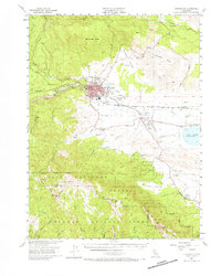
 1962 Susanville1965 Print · USGSNortheastern California's high desert and volcanic peaks meet in the early sixties, showing the region's timber and rail hubs in transition. Local historians can trace the Southern Pacific lines through Susanville and Litchfield, or explore the sprawling Sierra Army Depot and Lassen Volcanic National Park.2 unique versions available
 - 1968 Map of Susanville
 1968 Susanville1968 Print · USGSThe high Sierras and the Great Basin collide in the late 1960s, showing a landscape of volcanic peaks, timber settlements, and desert plains. Genealogists and researchers can trace historic rail lines like the Western Pacific or locate residents in Susanville, Westwood, and Janesville.
 - 1972 Map of Diamond Mtn
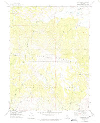 1972 Diamond Mtn1972 Print · USGSThe high Diamond Mountains in the early 1970s reveal a landscape of forest management and early pioneer history. Researchers can locate the Peter Lassen Grave, trace the Skyline Motorway, and find remote landmarks like Richmond Sch.3 unique versions available
 - 1975 Map of Susanville NE, 1979 Print
 1975 Susanville NE1979 Print · USGSThe Lassen County high desert meets the irrigated Susan River valley in this mid-seventies photographic survey. Genealogists and historians can trace the rural layouts of Johnstonville and Leavitt or the steep terrain around Antelope Mtn.2 unique versions available
 - 1975 Map of Susanville NW, 1980 Print
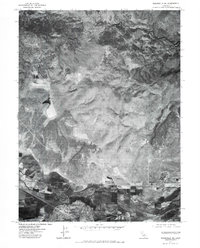
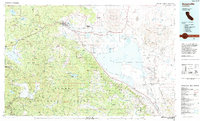
 1975 Susanville NW1980 Print · USGSNorthern California at the mid-seventies is documented in this detailed aerial perspective of the Lassen County seat. Researchers can trace the development of Susanville along the Susan River and the confluence of Piute Creek.
 - 1984 Map of Susanville
 1984 Susanville1984 Print · USGSLassen and Plumas counties in the mid-1980s showcase a high-altitude landscape of timber, military installations, and valley settlements. Genealogists and local historians can trace the rail corridors of the Southern Pacific and Western Pacific near Susanville or locate smaller locales like Crescent Mills and the Sierra Army Depot.2 unique versions available
 - 1988 Map of Susanville, 1989 Print
 1988 Susanville1989 Print · USGSThe high desert landscape around Susanville is captured here in the late eighties as the town grew along the Susan River. Local historians can trace the development of the Susanville Rancheria, locate the Lassen Cemetery, and see the footprint of Lassen College.2 unique versions available
 - 1988 Map of Litchfield, 1989 Print
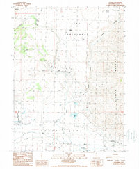 1988 Litchfield1989 Print · USGSHoney Lake Valley in the late eighties reveals a landscape of high-desert ranching and modern infrastructure. Researchers can trace the water history of Willow Creek and locate historic sites like Belfast, The Crossing, and Morgan Spring.
 - 1988 Map of Johnstonville, 1989 Print
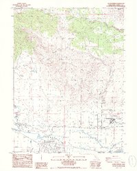 1988 Johnstonville1989 Print · USGSLassen County's high valley terrain is captured here in the late eighties as the region balanced its ranching roots with modern infrastructure. Researchers can trace the path of the Susan River or locate local landmarks like Johnstonville and the California Correctional Center.2 unique versions available
 - 1994 Map of Diamond Mountain, 1997 Print
 1994 Diamond Mountain1997 Print · USGSThe high sierra of Lassen and Plumas counties is captured here in the 1990s, detailing a landscape of forestry and remote heritage sites. Researchers can find the Peter Lassen Grave, the Richmond School, and isolated outposts like Wheeler Sheep Camp.2 unique versions available
 - 1995 Map of Susanville, 1998 Print
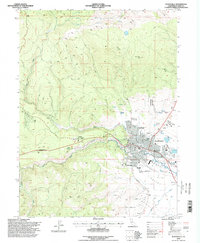 1995 Susanville1998 Print · USGSThe Lassen County seat thrives in the mid-nineties as a gateway between the Sierra Nevada and the Great Basin. Local researchers can trace family landmarks like Lassen Cemetery, Lassen College, and the sprawling Susanville Rancheria.
End of results
Showing maps 1-16 of 16
Top cities near Susanville
- Susanville historical maps
- Janesville historical maps
- Johnstonville historical maps
- Litchfield historical maps
Top neighborhoods of Susanville
Frequently asked questions
- What are the different types of historical maps available for Susanville?
- What is the oldest map of Susanville?
- Where can I purchase historical maps of Susanville for my home or office?
- Where can I download high-res historical maps of Susanville?
- Are there historical topographic maps available for Susanville?
- Is there historical aerial imagery available for Susanville?
- Where are historical maps of Susanville sourced from?