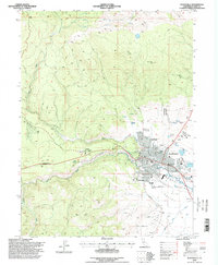
1995 Map of Susanville
USGS Topo · Published 1998About this map
Susanville serves as the hub of activity in this 1990s study, situated where the Susan River flows into the broad expanse of Honey Valley. The city's layout is well-established, showing key civic landmarks such as the Forest Supervisor Office and the County Fairgrounds. Higher education and local history are anchored by Lassen College and the Lassen Cemetery, while the Susanville Rancheria marks a significant cultural presence on the landscape.
Find a feature on this map
38 named features on this map. Tap any name to fly to it.
Don’t see what you’re looking for? This feature index may not catch every label — zoom into the map to look around manually.
Map Details
Editions of this 1995 Susanville Map
This is the sole edition of this map. No revisions or reprints were ever made.
Other maps of this area

1886 · Honey Lake
USGS Topo · 1:250,000

1891 · Honey Lake
USGS Topo · 1:250,000

1893 · Honey Lake
USGS Topo · 1:250,000

1954 · Susanville
USGS Topo · 1:62,500

1954 · Fredonyer Peak
USGS Topo · 1:62,500

1955 · Westwood
USGS Topo · 1:62,500

1955 · Westwood
USGS Topo · 1:250,000

1956 · Antelope Mtn
USGS Topo · 1:62,500

1958 · Westwood
USGS Topo · 1:250,000

1959 · Westwood
USGS Topo · 1:250,000