1980s Maps of Viewland, California
Explore 2 historic maps of Viewland from the 1980s. These maps offer a rare glimpse into what life looked like during the 1980s — showing old roads, neighborhoods, homes, and landmarks that have changed or disappeared over time.
Whether you're researching your family's past, planning a metal detecting trip, or studying how Viewland's landscape evolved across the 1980s, these high-resolution maps are a powerful tool for exploring the history of this region.
- Focus on a specific era: All maps on this page are from the 1980s, giving you a focused view of this time period.
- See what’s changed: Compare century-old streets, trails, and buildings to today's modern landscape using overlays and satellite layers.
- Research with precision: Use these maps for genealogy, historical research, land use analysis, or educational projects.
- View, download, or print: Maps are fully viewable online in high resolution, and can be downloaded or printed for your own records.
Start exploring Viewland's history through authentic maps from the 1980s. This is your window into the past.
Viewland, CA maps
(2)- 1984 Map of Susanville
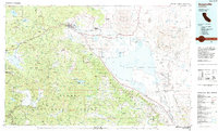 1984 Susanville1984 Print · USGSLassen and Plumas counties in the mid-1980s showcase a high-altitude landscape of timber, military installations, and valley settlements. Genealogists and local historians can trace the rail corridors of the Southern Pacific and Western Pacific near Susanville or locate smaller locales like Crescent Mills and the Sierra Army Depot.2 unique versions available
 - 1988 Map of Shaffer Mtn, 1989 Print
 1988 Shaffer Mtn1989 Print · USGSLassen County's high desert terrain is captured here in the late eighties as the mountain peaks meet the basin floor. Researchers can trace land use through features like the Dairy at Tanner, isolated Corral sites, and early communications at the Radio Towers.
End of results
Showing maps 1-2 of 2
Top cities near Viewland
Frequently asked questions
- What are the different types of historical maps available for Viewland?
- What is the oldest map of Viewland?
- Where can I purchase historical maps of Viewland for my home or office?
- Where can I download high-res historical maps of Viewland?
- Are there historical topographic maps available for Viewland?
- Is there historical aerial imagery available for Viewland?
- Where are historical maps of Viewland sourced from?