1980s Maps of Westwood, California
Explore 2 historic maps of Westwood from the 1980s. These maps offer a rare glimpse into what life looked like during the 1980s — showing old roads, neighborhoods, homes, and landmarks that have changed or disappeared over time.
Whether you're researching your family's past, planning a metal detecting trip, or studying how Westwood's landscape evolved across the 1980s, these high-resolution maps are a powerful tool for exploring the history of this region.
- Focus on a specific era: All maps on this page are from the 1980s, giving you a focused view of this time period.
- See what’s changed: Compare century-old streets, trails, and buildings to today's modern landscape using overlays and satellite layers.
- Research with precision: Use these maps for genealogy, historical research, land use analysis, or educational projects.
- View, download, or print: Maps are fully viewable online in high resolution, and can be downloaded or printed for your own records.
Start exploring Westwood's history through authentic maps from the 1980s. This is your window into the past.
Westwood, CA maps
(2)- 1980 Map of Westwood West
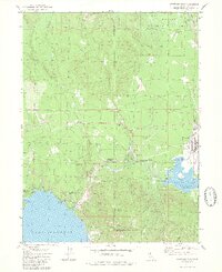 1980 Westwood West1980 Print · USGSNortheastern California at the start of the 1980s reveals a landscape shaped by water management and timber transport. Genealogists and historians can trace the growth of Westwood and Hamilton Branch alongside the Western Pacific railroad and the Indian Ole Dam.2 unique versions available
 - 1989 Map of Lake Almanor, 1990 Print
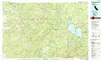 1989 Lake Almanor1990 Print · USGSUpper Plumas and Tehama counties appear here in the late eighties as a landscape of timber, volcanic peaks, and high-country reservoirs. Genealogists and historians can trace settlements from Chester and Westwood to mountain outposts like Mineral and Jonesville.2 unique versions available
End of results
Showing maps 1-2 of 2
Top cities near Westwood
Frequently asked questions
- What are the different types of historical maps available for Westwood?
- What is the oldest map of Westwood?
- Where can I purchase historical maps of Westwood for my home or office?
- Where can I download high-res historical maps of Westwood?
- Are there historical topographic maps available for Westwood?
- Is there historical aerial imagery available for Westwood?
- Where are historical maps of Westwood sourced from?