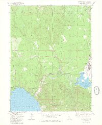
1980 Map of Westwood West
USGS Topo · Published 1980About this map
Lake Almanor and Mountain Meadows Reservoir define this Plumas County landscape, capturing the area's transition into a recreation and timber hub by the late 1970s. The town of Westwood sits at the eastern edge, showing the local High Sch and an isolated Grave near the Western Pacific rail line. The industrial footprint of the era is evident through several borrow pits and a Quarry, while the Westwood Airport and Clear Creek Junction serve as local transport nodes. Along the shoreline, residential and resort developments like Peninsula Village and Hamilton Branch indicate the growing importance of the lakefront. Finer historical details include a Historical Marker north of Clear Creek and the Indian Ole Dam structure at the reservoir's edge, offering specific points of interest for local historians and land use researchers.
Find a feature on this map
41 named features on this map. Tap any name to fly to it.
Don’t see what you’re looking for? This feature index may not catch every label — zoom into the map to look around manually.
Map Details
Editions of this 1980 Westwood West Map
2 editions found
Other maps of this area

1886 · Honey Lake
USGS Topo · 1:250,000

1886 · Lassen Peak
USGS Topo · 1:250,000

1891 · Honey Lake
USGS Topo · 1:250,000

1892 · Lassen Peak
USGS Topo · 1:250,000

1893 · Honey Lake
USGS Topo · 1:250,000

1894 · Lassen Peak
USGS Topo · 1:250,000

1950 · Greenville
USGS Topo · 1:62,500

1955 · Westwood
USGS Topo · 1:62,500

1955 · Almanor
USGS Topo · 1:62,500

1955 · Westwood
USGS Topo · 1:250,000