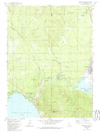
1980 Map of Westwood West
USGS Topo · Published 1985About this map
Westwood serves as the primary hub in this Sierra Nevada landscape, shown here at the transition between the Lassen and Plumas county lines. The community is defined by its relationship to the water and the rails, with the Western Pacific railroad skirting the edge of the Mountain Meadows Reservoir and passing through Clear Creek Junction. To the southwest, the shoreline of Lake Almanor reaches into the frame at Big Cove, where the growing community of Hamilton and the Peninsula Village development sit near the water's edge. Much of the northern terrain remains protected under the Lassen National Forest, characterized by numerous water sources like Brush Spring and Tamarack Springs. The presence of an Indian Ole Dam and a Historical Marker near Clear Creek suggests layers of local history preserved in the landscape alongside infrastructure like the Westwood Airport.
Find a feature on this map
32 named features on this map. Tap any name to fly to it.
Don’t see what you’re looking for? This feature index may not catch every label — zoom into the map to look around manually.
Map Details
Editions of this 1980 Westwood West Map
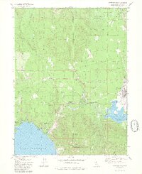
2 editions found
Other maps of this area

1886 · Honey Lake
USGS Topo · 1:250,000

1886 · Lassen Peak
USGS Topo · 1:250,000

1891 · Honey Lake
USGS Topo · 1:250,000

1892 · Lassen Peak
USGS Topo · 1:250,000

1893 · Honey Lake
USGS Topo · 1:250,000

1894 · Lassen Peak
USGS Topo · 1:250,000

1950 · Greenville
USGS Topo · 1:62,500

1955 · Westwood
USGS Topo · 1:62,500

1955 · Almanor
USGS Topo · 1:62,500

1955 · Westwood
USGS Topo · 1:250,000