1990s Maps of Las Lomas, Duarte
Explore 1 historic maps of Las Lomas from the 1990s. These maps offer a rare glimpse into what life looked like during the 1990s — showing old roads, neighborhoods, homes, and landmarks that have changed or disappeared over time.
Whether you're researching your family's past, planning a metal detecting trip, or studying how Las Lomas's landscape evolved across the 1990s, these high-resolution maps are a powerful tool for exploring the history of this region.
- Focus on a specific era: All maps on this page are from the 1990s, giving you a focused view of this time period.
- See what’s changed: Compare century-old streets, trails, and buildings to today's modern landscape using overlays and satellite layers.
- Research with precision: Use these maps for genealogy, historical research, land use analysis, or educational projects.
- View, download, or print: Maps are fully viewable online in high resolution, and can be downloaded or printed for your own records.
Start exploring Las Lomas's history through authentic maps from the 1990s. This is your window into the past.
Las Lomas, Duarte maps
(1)- 1995 Map of Azusa, 1999 Print
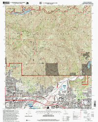 1995 Azusa1999 Print · USGSThe foothill communities of the San Gabriel Valley meet the wilderness in the mid-1990s, showcasing a landscape of suburban growth and rugged forest. Researchers can locate long-standing institutions like Azusa Pacific University, the City of Hope National Medical Center, and the historic Liveoak Cemetery.
End of results
Showing maps 1-1 of 1
Top cities near Las Lomas
- Los Angeles historical maps
- Pomona historical maps
- Pasadena historical maps
- Fullerton historical maps
- Downey historical maps
- El Monte historical maps
See more
Frequently asked questions
- What are the different types of historical maps available for Las Lomas?
- What is the oldest map of Las Lomas?
- Where can I purchase historical maps of Las Lomas for my home or office?
- Where can I download high-res historical maps of Las Lomas?
- Are there historical topographic maps available for Las Lomas?
- Is there historical aerial imagery available for Las Lomas?
- Where are historical maps of Las Lomas sourced from?