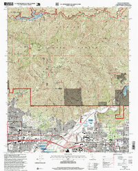
1995 Map of Azusa
USGS Topo · Published 1999About this map
The San Gabriel Wilderness and Angeles National Forest dominate the northern landscape of this mid-1990s survey, where steep canyons like Fish Canyon and Roberts Canyon drop sharply toward the urbanized San Gabriel Valley. The southern portion of the map captures the dense development of Azusa, Duarte, and Monrovia just before the turn of the millennium. This era shows the critical infrastructure managing the region's water and geography, from the Morris Reservoir on the San Gabriel River to the massive Santa Fe Flood Control Basin. Educational and medical institutions serve as local anchors, including the sprawling City of Hope National Medical Center and Azusa Pacific University. The presence of the Metrolink rail line and major thoroughfares like Foothill Blvd highlights the transportation network connecting these foothill communities to the broader Los Angeles basin.
Find a feature on this map
101 named features on this map. Tap any name to fly to it.
Don’t see what you’re looking for? This feature index may not catch every label — zoom into the map to look around manually.
Map Details
Editions of this 1995 Azusa Map
This is the sole edition of this map. No revisions or reprints were ever made.
Other maps of this area

1894 · Los Angeles
USGS Topo · 1:62,500

1894 · Pomona
USGS Topo · 1:62,500

1896 · Pasadena
USGS Topo · 1:62,500

1897 · Pomona
USGS Topo · 1:62,500

1898 · Pomona
USGS Topo · 1:62,500

1900 · Pasadena
USGS Topo · 1:62,500

1900 · Tujunga
USGS Topo · 1:62,500

1900 · Los Angeles
USGS Topo · 1:62,500

1901 · Southern California Sheet No. 1
USGS Topo · 1:250,000

1903 · Rock Creek
USGS Topo · 1:62,500