1970s Maps of Studio City Neighborhood Council District, Los Angeles
Explore 4 historic maps of Studio City Neighborhood Council District from the 1970s. These maps offer a rare glimpse into what life looked like during the 1970s — showing old roads, neighborhoods, homes, and landmarks that have changed or disappeared over time.
Whether you're researching your family's past, planning a metal detecting trip, or studying how Studio City Neighborhood Council District's landscape evolved across the 1970s, these high-resolution maps are a powerful tool for exploring the history of this region.
- Focus on a specific era: All maps on this page are from the 1970s, giving you a focused view of this time period.
- See what’s changed: Compare century-old streets, trails, and buildings to today's modern landscape using overlays and satellite layers.
- Research with precision: Use these maps for genealogy, historical research, land use analysis, or educational projects.
- View, download, or print: Maps are fully viewable online in high resolution, and can be downloaded or printed for your own records.
Start exploring Studio City Neighborhood Council District's history through authentic maps from the 1970s. This is your window into the past.
Studio City Neighborhood Council District, Los Angeles maps
(4)- 1975 Map of Los Angeles, 1977 Print
 1975 Los Angeles1977 Print · USGSSouthern California is captured in a period of significant growth during the mid-seventies, showing the urban sprawl from the coast to the high desert. Researchers can trace the development of the Pacific Coast Hwy and find aerospace landmarks like Edwards Air Force Base and the Flight Test Center (NASA).2 unique versions available
 - 1976 Map of Burbank, 1977 Print
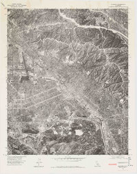 1976 Burbank1977 Print · USGSCovers Studio City Neighborhood Council District, including Los Angeles, Glendale, and other nearby areas
 - 1976 Map of Van Nuys, 1980 Print
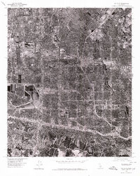 1976 Van Nuys1980 Print · USGSThe San Fernando Valley is seen in the mid-1970s as a fully realized suburban landscape defined by its famous street grid and industrial hubs. Researchers can trace the mid-century development of Van Nuys and North Hollywood alongside the Los Angeles River.
 - 1979 Map of Los Angeles
 1979 Los Angeles1979 Print · USGSSouthern California at the close of the 1970s reveals a sprawling network of suburban growth and massive infrastructure projects. Researchers can trace established rail lines like the Southern Pacific alongside newer settlements and landmarks like Virginia Colony and Griffith Park.
End of results
Showing maps 1-4 of 4
Frequently asked questions
- What are the different types of historical maps available for Studio City Neighborhood Council District?
- What is the oldest map of Studio City Neighborhood Council District?
- Where can I purchase historical maps of Studio City Neighborhood Council District for my home or office?
- Where can I download high-res historical maps of Studio City Neighborhood Council District?
- Are there historical topographic maps available for Studio City Neighborhood Council District?
- Is there historical aerial imagery available for Studio City Neighborhood Council District?
- Where are historical maps of Studio City Neighborhood Council District sourced from?