
1975 Map of Los Angeles
USGS Topo · Published 1977About this map
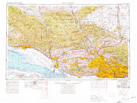
Los Angeles and the surrounding Southern California coastline are documented here during the mid-1970s, illustrating the dense urban expansion from Santa Monica east through Pasadena and El Monte. The map provides a detailed view of the regional infrastructure, including the Southern Pacific rail lines and the iconic Pacific Coast Hwy winding along the Santa Barbara Channel. To the north, the transition from the Santa Ynez Mountains to the high desert is marked by federal installations like Edwards Air Force Base and the Flight Test Center (NASA) near Rosamond Lake. These aeronautical and military sites contrast with the protected landscapes of the Los Padres National Forest and the San Rafael Wilderness, showing how mid-century defense and aerospace sectors shared the landscape with significant early conservation efforts and expanding suburban centers like Thousand Oaks and Simi Valley.
Find a feature on this map
53 named features on this map. Tap any name to fly to it.
Don’t see what you’re looking for? This feature index may not catch every label — zoom into the map to look around manually.
Map Details
Editions of this 1975 Los Angeles Map
2 editions found
Other maps of this area

1894 · Los Angeles
USGS Topo · 1:62,500

1894 · Pomona
USGS Topo · 1:62,500

1896 · Pasadena
USGS Topo · 1:62,500

1896 · Anaheim
USGS Topo · 1:62,500

1896 · Redondo
USGS Topo · 1:62,500

1896 · Santa Monica
USGS Topo · 1:62,500

1896 · Downey
USGS Topo · 1:62,500

1897 · Pomona
USGS Topo · 1:62,500

1898 · Pomona
USGS Topo · 1:62,500

1898 · Santa Monica
USGS Topo · 1:62,500