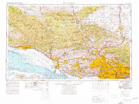
1975 Map of Los Angeles
USGS Topo · Published 1977About this map
The Santa Monica Mountains and the extensive urbanization of the Los Angeles basin dominate this mid-1970s topographic study. This map captures the sprawling Southern California landscape before decades of further development, detailing the corridor from Santa Barbara through Thousand Oaks and into the heart of the metropolitan region. Significant federal and environmental footprints are visible, including the Edwards Air Force Base and the Flight Test Center (NASA) in the Mojave Desert, alongside conservation efforts like the Sespe Condor Sanctuary. The complex interplay of geography is shown through the depths of the Santa Barbara Channel and the heights of the San Gabriel Mountains, while the Southern Pacific railroad and major freeway systems like the 101 and 405 illustrate the infrastructure supporting the region's massive post-war growth.
Find a feature on this map
116 named features on this map. Tap any name to fly to it.
Don’t see what you’re looking for? This feature index may not catch every label — zoom into the map to look around manually.
Map Details
Editions of this 1975 Los Angeles Map
2 editions found
Other maps of this area

1894 · Los Angeles
USGS Topo · 1:62,500

1894 · Pomona
USGS Topo · 1:62,500

1896 · Pasadena
USGS Topo · 1:62,500

1896 · Anaheim
USGS Topo · 1:62,500

1896 · Redondo
USGS Topo · 1:62,500

1896 · Santa Monica
USGS Topo · 1:62,500

1896 · Downey
USGS Topo · 1:62,500

1897 · Pomona
USGS Topo · 1:62,500

1898 · Pomona
USGS Topo · 1:62,500

1898 · Santa Monica
USGS Topo · 1:62,500