1940s Maps of Malibu, California
Explore 5 historic maps of Malibu from the 1940s. These maps offer a rare glimpse into what life looked like during the 1940s — showing old roads, neighborhoods, homes, and landmarks that have changed or disappeared over time.
Whether you're researching your family's past, planning a metal detecting trip, or studying how Malibu's landscape evolved across the 1940s, these high-resolution maps are a powerful tool for exploring the history of this region.
- Focus on a specific era: All maps on this page are from the 1940s, giving you a focused view of this time period.
- See what’s changed: Compare century-old streets, trails, and buildings to today's modern landscape using overlays and satellite layers.
- Research with precision: Use these maps for genealogy, historical research, land use analysis, or educational projects.
- View, download, or print: Maps are fully viewable online in high resolution, and can be downloaded or printed for your own records.
Start exploring Malibu's history through authentic maps from the 1940s. This is your window into the past.
Malibu, CA maps
(5)- 1943 Map of Triunfo Pass
 1943 Triunfo Pass1943 Print · USGSThe Conejo Valley and Santa Monica Mountains are shown here during the early war years, when ranching and small coastal outposts defined the region. Local researchers can locate family landholdings like Fillmore Ranch or trace the early development of the Thousand Oaks Community and Newbury Park.
 - 1944 Map of Calabasas
 1944 Calabasas1944 Print · USGSMid-century Los Angeles County unfolds here, showing the grid of the San Fernando Valley meeting the Santa Monica Mountains. Trace old ranch boundaries at Platt Ranch or locate early landmarks like the Will Rogers Memorial and Topanga Lookout.
 - 1949 Map of Los Angeles
 1949 Los Angeles1949 Print · USGSSouthern California and the South Coast appear at the onset of the post-war boom, from the Channel Islands to the Mojave Desert. Trace early aviation sites like Lockheed Air Terminal and mining history at the Redrock Quicksilver Mine and Redrover Mine.2 unique versions available
 - 1949 Map of Long Beach
 1949 Long Beach1949 Print · USGSSouthern California at the start of the post-war boom shows the rapid development of the Los Angeles basin and the South Bay. Genealogists and historians can trace the evolution of early suburbs like Gardena and Lynwood or the coastal defenses at Ft MacArthur Lower Reservation.2 unique versions available
 - 1949 Map of Triunfo Pass, 1958 Print
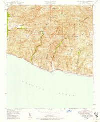 1949 Triunfo Pass1958 Print · USGSThe coastal Santa Monica Mountains meet the Pacific in the late 1940s, showing a landscape of deep canyons and early highway development. Genealogists and historians can locate rural landmarks like Yerba Buena Sch, the Triunfo Lookout, and the seaside Solromar.3 unique versions available
End of results
Showing maps 1-5 of 5
Top cities near Malibu
- Los Angeles historical maps
- Thousand Oaks historical maps
- Simi Valley historical maps
- Santa Monica historical maps
- Camarillo historical maps
- Calabasas historical maps
See more
Top neighborhoods of Malibu
- Malibu Beach historical maps
- Trancas historical maps
- Malibu West historical maps
- Las Flores historical maps
- Malibu Country Estates historical maps
- Malibu Riviera historical maps
Frequently asked questions
- What are the different types of historical maps available for Malibu?
- What is the oldest map of Malibu?
- Where can I purchase historical maps of Malibu for my home or office?
- Where can I download high-res historical maps of Malibu?
- Are there historical topographic maps available for Malibu?
- Is there historical aerial imagery available for Malibu?
- Where are historical maps of Malibu sourced from?