1930s Maps of Pasadena, California
Explore 3 historic maps of Pasadena from the 1930s. These maps offer a rare glimpse into what life looked like during the 1930s — showing old roads, neighborhoods, homes, and landmarks that have changed or disappeared over time.
Whether you're researching your family's past, planning a metal detecting trip, or studying how Pasadena's landscape evolved across the 1930s, these high-resolution maps are a powerful tool for exploring the history of this region.
- Focus on a specific era: All maps on this page are from the 1930s, giving you a focused view of this time period.
- See what’s changed: Compare century-old streets, trails, and buildings to today's modern landscape using overlays and satellite layers.
- Research with precision: Use these maps for genealogy, historical research, land use analysis, or educational projects.
- View, download, or print: Maps are fully viewable online in high resolution, and can be downloaded or printed for your own records.
Start exploring Pasadena's history through authentic maps from the 1930s. This is your window into the past.
Pasadena, CA maps
(3)- 1933 Map of Sierra Madre
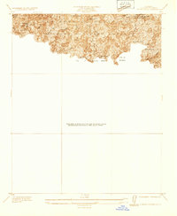 1933 Sierra Madre1933 Print · USGSThe foothills of the San Gabriel Mountains come alive in the 1930s as residential growth meets the rugged canyons of the Angeles National Forest. Genealogists and hikers can trace early mountain retreats like Orchard Camp, Henninger Flats, and the First Water Resort.
 - 1934 Map of Mt. Lowe
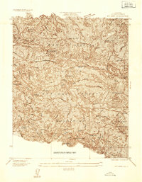 1934 Mt. Lowe1934 Print · USGSThe San Gabriel Mountains in the mid-1930s were a hub of high-altitude leisure and mountain engineering. Researchers can trace the legendary Mt Lowe Ry to Echo Mtn, find the Dawn Mine, or locate remote camps like Colby Ranch.
 - 1939 Map of Mt. Lowe
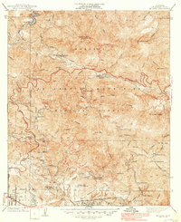 1939 Mt. Lowe1939 Print · USGSThe San Gabriel Mountains in the late 1930s served as a premier getaway for Southern Californians, reachable via remarkable rail engineering. You can trace the historic Mount Lowe Incline up to the Mt Lowe Tavern or locate old forest retreats like Switzers Camp.5 unique versions available
End of results
Showing maps 1-3 of 3
Top cities near Pasadena
- Los Angeles historical maps
- Glendale historical maps
- Inglewood historical maps
- Downey historical maps
- El Monte historical maps
- West Covina historical maps
See more
Top neighborhoods of Pasadena
- Science Village historical maps
- Linda Vista historical maps
- Old Pasadena historical maps
- Lamanda Park historical maps
- Madison Heights historical maps
- Bungalow Heaven historical maps
See more
Frequently asked questions
- What are the different types of historical maps available for Pasadena?
- What is the oldest map of Pasadena?
- Where can I purchase historical maps of Pasadena for my home or office?
- Where can I download high-res historical maps of Pasadena?
- Are there historical topographic maps available for Pasadena?
- Is there historical aerial imagery available for Pasadena?
- Where are historical maps of Pasadena sourced from?