1990s Maps of Pasadena, California
Explore 3 historic maps of Pasadena from the 1990s. These maps offer a rare glimpse into what life looked like during the 1990s — showing old roads, neighborhoods, homes, and landmarks that have changed or disappeared over time.
Whether you're researching your family's past, planning a metal detecting trip, or studying how Pasadena's landscape evolved across the 1990s, these high-resolution maps are a powerful tool for exploring the history of this region.
- Focus on a specific era: All maps on this page are from the 1990s, giving you a focused view of this time period.
- See what’s changed: Compare century-old streets, trails, and buildings to today's modern landscape using overlays and satellite layers.
- Research with precision: Use these maps for genealogy, historical research, land use analysis, or educational projects.
- View, download, or print: Maps are fully viewable online in high resolution, and can be downloaded or printed for your own records.
Start exploring Pasadena's history through authentic maps from the 1990s. This is your window into the past.
Pasadena, CA maps
(3)- 1995 Map of Pasadena, 1999 Print
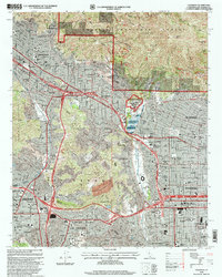 1995 Pasadena1999 Print · USGSThe San Gabriel Valley is captured in the mid-nineties as the urban sprawl of Pasadena and Glendale meets the southern canyons of the Angeles National Forest. Researchers can trace institutional landmarks like the Jet Propulsion Laboratory and the historic Rose Bowl.
 - 1995 Map of Mount Wilson, 1999 Print
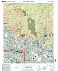 1995 Mount Wilson1999 Print · USGSThe San Gabriel foothills meet the suburban edges of Pasadena and Monrovia in the mid-nineties. Researchers can locate the Observatory at Mount Wilson or trace the Gabrielino Trail past Henninger Flats.
 - 1995 Map of Condor Peak, 1999 Print
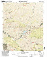 1995 Condor Peak1999 Print · USGSThe northern reaches of Los Angeles are mapped during the mid-nineties as suburban growth pressed against the steep canyons of the San Gabriel Mountains. Researchers can locate the Big Tujunga Dam, the historic Ybarra Ranch, and remote sites like the Lodestone Mine.
End of results
Showing maps 1-3 of 3
Top cities near Pasadena
- Los Angeles historical maps
- Glendale historical maps
- Inglewood historical maps
- Downey historical maps
- El Monte historical maps
- West Covina historical maps
See more
Top neighborhoods of Pasadena
- Science Village historical maps
- Linda Vista historical maps
- Old Pasadena historical maps
- Lamanda Park historical maps
- Madison Heights historical maps
- Bungalow Heaven historical maps
See more
Frequently asked questions
- What are the different types of historical maps available for Pasadena?
- What is the oldest map of Pasadena?
- Where can I purchase historical maps of Pasadena for my home or office?
- Where can I download high-res historical maps of Pasadena?
- Are there historical topographic maps available for Pasadena?
- Is there historical aerial imagery available for Pasadena?
- Where are historical maps of Pasadena sourced from?