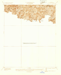
1933 Map of Sierra Madre
USGS Topo · Published 1933About this map
The San Gabriel Mountains rise sharply above the developing San Gabriel Valley, where the interface between the City of Sierra Madre, City of Arcadia, and City of Monrovia meets the southern edge of the Angeles National Forest. This 1933 survey reveals a landscape defined by canyons and early 20th-century mountain recreation, featuring numerous retreats such as Orchard Camp, Roberts Camp, and the First Water Resort. The intricate network of human activity in the hills is marked by the Toll Road, the Wilson Trail, and several Firebreak lines designed to protect the watershed. Infrastructure like the Santa Anita Dam and Sierra Madre Dam highlights the era's focus on water management for the growing communities below. Local resource management is also evident at the L A Co Nursery near Henninger Flats, reflecting the county's early conservation efforts within the steep terrain of Eaton Canyon and Santa Anita Canyon.
Find a feature on this map
24 named features on this map. Tap any name to fly to it.
Don’t see what you’re looking for? This feature index may not catch every label — zoom into the map to look around manually.
Map Details
Editions of this 1933 Sierra Madre Map
This is the sole edition of this map. No revisions or reprints were ever made.
Other maps of this area

1894 · Los Angeles
USGS Topo · 1:62,500

1894 · Pomona
USGS Topo · 1:62,500

1896 · Pasadena
USGS Topo · 1:62,500

1897 · Pomona
USGS Topo · 1:62,500

1898 · Pomona
USGS Topo · 1:62,500

1900 · Pasadena
USGS Topo · 1:62,500

1900 · Los Angeles
USGS Topo · 1:62,500

1901 · Southern California Sheet No. 1
USGS Topo · 1:250,000

1904 · Pomona
USGS Topo · 1:62,500

1904 · Southern California Sheet No. 1
USGS Topo · 1:250,000