
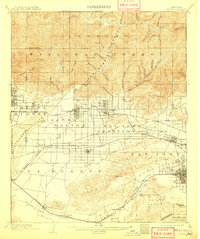
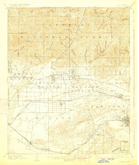
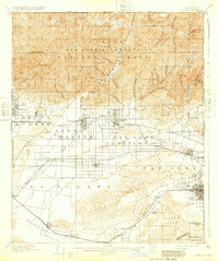
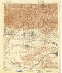
1904 Map of Pomona
USGS Topo · Published 1904About this map
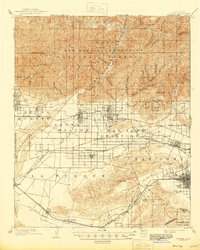
The San Gabriel Timberland Reserve dominates the northern half of this landscape, a complex system of deep canyons like Graveyard Canyon and Horse Canyon that drain into the San Gabriel River. Below the foothills, the late 19th-century citrus belt is in its formative years, shaped by an intricate network of irrigation including the Azusa Ditch and Covina Canal.
Find a feature on this map
83 named features on this map. Tap any name to fly to it.
Don’t see what you’re looking for? This feature index may not catch every label — zoom into the map to look around manually.
Map Details
Editions of this 1904 Pomona Map
7 editions found

Other maps of this area

1894 · Los Angeles
USGS Topo · 1:62,500

1894 · Pomona
USGS Topo · 1:62,500

1896 · Pasadena
USGS Topo · 1:62,500

1896 · Anaheim
USGS Topo · 1:62,500

1896 · Downey
USGS Topo · 1:62,500

1897 · Pomona
USGS Topo · 1:62,500

1897 · Cucamonga
USGS Topo · 1:62,500

1898 · Pomona
USGS Topo · 1:62,500

1898 · Anaheim
USGS Topo · 1:62,500

1899 · Downey
USGS Topo · 1:62,500