1930s Maps of Three Points, California
Explore 2 historic maps of Three Points from the 1930s. These maps offer a rare glimpse into what life looked like during the 1930s — showing old roads, neighborhoods, homes, and landmarks that have changed or disappeared over time.
Whether you're researching your family's past, planning a metal detecting trip, or studying how Three Points's landscape evolved across the 1930s, these high-resolution maps are a powerful tool for exploring the history of this region.
- Focus on a specific era: All maps on this page are from the 1930s, giving you a focused view of this time period.
- See what’s changed: Compare century-old streets, trails, and buildings to today's modern landscape using overlays and satellite layers.
- Research with precision: Use these maps for genealogy, historical research, land use analysis, or educational projects.
- View, download, or print: Maps are fully viewable online in high resolution, and can be downloaded or printed for your own records.
Start exploring Three Points's history through authentic maps from the 1930s. This is your window into the past.
Three Points, CA maps
(2)- 1933 Map of Manzana
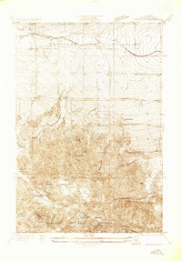 1933 Manzana1933 Print · USGSLos Angeles County ranching and water engineering intersect in the early 1930s along the southern edge of the Antelope Valley. Researchers can trace early settlements and social hubs like Pecks Ranch, the Pine Canyon Sch, and the Tweedy Lake Club.
 - 1938 Map of Manzana
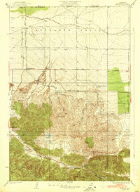 1938 Manzana1938 Print · USGSThe northern reaches of Los Angeles County and the Antelope Valley come alive in this mid-1930s survey of ranch lands and mountain canyons. Trace the historical path of the Los Angeles Aqueduct and locate family landmarks like Manzana Ranch, Spencer Ranch, and the Big Chief Mine.3 unique versions available
End of results
Showing maps 1-2 of 2
Frequently asked questions
- What are the different types of historical maps available for Three Points?
- What is the oldest map of Three Points?
- Where can I purchase historical maps of Three Points for my home or office?
- Where can I download high-res historical maps of Three Points?
- Are there historical topographic maps available for Three Points?
- Is there historical aerial imagery available for Three Points?
- Where are historical maps of Three Points sourced from?