1990s Maps of Val Verde, California
Explore 2 historic maps of Val Verde from the 1990s. These maps offer a rare glimpse into what life looked like during the 1990s — showing old roads, neighborhoods, homes, and landmarks that have changed or disappeared over time.
Whether you're researching your family's past, planning a metal detecting trip, or studying how Val Verde's landscape evolved across the 1990s, these high-resolution maps are a powerful tool for exploring the history of this region.
- Focus on a specific era: All maps on this page are from the 1990s, giving you a focused view of this time period.
- See what’s changed: Compare century-old streets, trails, and buildings to today's modern landscape using overlays and satellite layers.
- Research with precision: Use these maps for genealogy, historical research, land use analysis, or educational projects.
- View, download, or print: Maps are fully viewable online in high resolution, and can be downloaded or printed for your own records.
Start exploring Val Verde's history through authentic maps from the 1990s. This is your window into the past.
Val Verde, CA maps
(2)- 1991 Map of Val Verde, 1995 Print
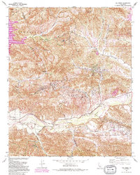 1991 Val Verde1995 Print · USGSThe northern Santa Susana Mountains meet the Santa Clara River in the 1990s, revealing an era of intense oil extraction and ranching. Genealogists and historians can trace family holdings like Lechler Ranch alongside industrial landmarks like Mayo Spur and the Ramona Oil Field.
 - 1995 Map of Val Verde, 1999 Print
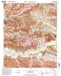 1995 Val Verde1999 Print · USGSNorth of Los Angeles in the mid-nineties, the Santa Clara River valley remained a landscape of active oil fields and sprawling ranches. Genealogists and local historians can trace the foundations of Val Verde, locate the Cem near Hasley, and explore the legacy of Stanley Ranch.
End of results
Showing maps 1-2 of 2
Top cities near Val Verde
- Los Angeles historical maps
- Santa Clarita historical maps
- Thousand Oaks historical maps
- Simi Valley historical maps
- Moorpark historical maps
- San Fernando historical maps
See more
Frequently asked questions
- What are the different types of historical maps available for Val Verde?
- What is the oldest map of Val Verde?
- Where can I purchase historical maps of Val Verde for my home or office?
- Where can I download high-res historical maps of Val Verde?
- Are there historical topographic maps available for Val Verde?
- Is there historical aerial imagery available for Val Verde?
- Where are historical maps of Val Verde sourced from?