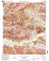
1995 Map of Val Verde
USGS Topo · Published 1999About this map
Val Verde and the surrounding canyonlands of the Santa Susana Mountains define this mid-1990s landscape at the northern edge of Los Angeles County. The map documents an area deeply shaped by the petroleum industry, evidenced by the dense concentration of oil wells and wells north of the Santa Clara River. Local history is preserved through named landmarks like Stanley Ranch and Lechler Ranch, while the rugged geography is carved by significant drainage systems including San Martinez Grande Canyon and Chiquito Canyon. To the west, the reach of Lake Piru is visible within the Temescal region. The infrastructure of the period is highlighted by historical routes such as Telegraph Road and the San Martinez Road, which connect the scattered settlements of Del Valle and Hasley across the complex terrain.
Find a feature on this map
41 named features on this map. Tap any name to fly to it.
Don’t see what you’re looking for? This feature index may not catch every label — zoom into the map to look around manually.
Map Details
Editions of this 1995 Val Verde Map
This is the sole edition of this map. No revisions or reprints were ever made.
Other maps of this area

1900 · Piru
USGS Topo · 1:62,500

1903 · Tejon
USGS Topo · 1:125,000

1903 · Camulos
USGS Topo · 1:125,000

1903 · Santa Susana
USGS Topo · 1:62,500

1921 · Piru
USGS Topo · 1:62,500
1929 · Pico
USGS Topo · 1:24,000

1931 · Whitaker Peak
USGS Topo · 1:24,000

1931 · Santa Felicia Canyon
USGS Topo · 1:24,000

1931 · Castaic
USGS Topo · 1:24,000

1935 · Santa Felicia Canyon
USGS Topo · 1:24,000