Old Maps of San Rafael, California for Hiking & Exploration
Hike through history with 56 historic maps of San Rafael. Explore old trails, ghost towns, and forgotten backroads — perfect for outdoor adventurers and local explorers.
- Rediscover forgotten places: Map out old mining camps, roads, and footpaths that no longer exist on modern maps.
- Layer with modern tools: Combine with LiDAR or satellite views to plan hikes through historical terrain.
- Made for exploration: Popular among hikers, overlanders, and local history lovers.
Use these maps to find adventure and explore the hidden past of San Rafael.
San Rafael, CA maps
(56)- 1895 Map of San Francisco
 1895 San Francisco1895 Print · USGSThe San Francisco Bay Area thrives as a maritime and rail power at the close of the nineteenth century. Genealogists and researchers can trace early neighborhoods in Berkeley, the layout of the Presidio Military Reservation, and rail terminals like the Oakland Mole.
 - 1897 Map of Tamalpais
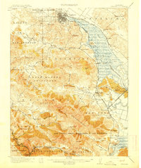
 1897 Tamalpais1897 Print · USGSMarin County's ridges and coastal lagoons are shown in the late nineteenth century as rail lines began to stitch together its small towns and land grants. Genealogists and historians can trace the early footprints of Eastland, Larkspur, and Woodville alongside the winding routes of the North Pacific Coast R. R.12 unique versions available
 - 1899 Map of San Francisco
 1899 San Francisco1899 Print · USGSThe Bay Area at the close of the nineteenth century reveals a burgeoning metropolis still tied to its maritime and rail roots. Trace the early layouts of the University of California and the Presidio, or locate the now-vanished Lone Mt. Cem. and Shell Mound.7 unique versions available
 - 1902 Map of Napa
 1902 Napa1902 Print · USGSThe Napa Valley and Carquinez Strait are captured at the turn of the century, showing a landscape defined by maritime military posts and early vineyards. Genealogists and historians can trace the Mare Island Navy Yard, the Insane Asylum, and rail stops at Zinfandel and Rutherford.6 unique versions available
 - 1914 Map of Petaluma
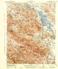
 1914 Petaluma1914 Print · USGSThe North Bay region near the turn of the century shows a landscape of tidal marshes and rising ridges connected by the Northwestern Pacific. Genealogists and historians can trace old family ranch sites like Freitas Ranch and numerous rural schoolhouses including Iowa School and Burdell School.5 unique versions available
 - 1915 Map of San Francisco
 1915 San Francisco1915 Print · USGSSan Francisco and the East Bay appear at a pivotal moment just before the First World War, featuring the grand layout of the Panama-Pacific International Exposition. Genealogists and historians can trace the early rail networks of the Key Route Pier, the industrial waterfront at Winehaven, and historic landmarks like Cliff House.6 unique versions available
 - 1916 Map of Mare Island
 1916 Mare Island1916 Print · USGSThe northern San Pablo Bay region comes alive in this survey, showcasing a landscape of tidal marshes and rail-driven growth during the mid-1910s. Researchers can trace the layout of the Mare Island Navy Yard, the remote rail stop at Wingo, and the rural classrooms of Fly School.4 unique versions available
 - 1941 Map of Tamalpais
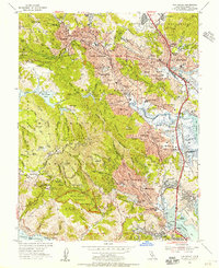
 1941 Tamalpais1941 Print · USGSMarin County's coastal defenses and rail-connected towns are captured here just as the nation entered World War II. Researchers can trace the early fortifications at Fort Cronkhite, the path of the Northwestern Pacific RR, and old landmarks like Bolinas School.
 - 1942 Map of Mare Island
 1942 Mare Island1942 Print · USGSThe northern reaches of San Pablo Bay come alive in this wartime survey, showing a landscape of vital naval yards and marshland agriculture. Genealogists and historians can trace rail depots like Napa Junction, rural landmarks like American Canyon School, and the industrial waterfronts of Vallejo and Oleum.
 - 1942 Map of Petaluma
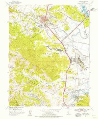
 1942 Petaluma1942 Print · USGSThe Marin and Sonoma county line runs through this early 1940s landscape of tidal marshes and ranch lands. Genealogists can trace family names at Mt Oliver Cemetery or find historic rural institutions like the Olompali School and St Vincent Station.
 - 1947 Map of Santa Rosa
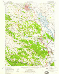
 1947 Santa Rosa1947 Print · USGSNorthern California in the late 1940s was a landscape of agricultural valleys and vital rail hubs. Trace the historic routes of the Northwestern Pacific through Healdsburg or explore the mid-century waterfronts of Vallejo and Benicia near Mare Island.
 - 1947 Map of San Francisco, 1948 Print
 1947 San Francisco1948 Print · USGSThe Bay Area in the late 1940s reveals a region transitioning from wartime intensity to post-war suburban growth. Trace the historic rail lines of the Southern Pacific RR or locate early military footprints at Fort Funston and Moffett Field.
 - 1947 Map of San Quentin, 1956 Print
 1947 San Quentin1956 Print · USGSThe San Francisco Bay area in the late 1940s reveals a landscape of ferry-connected shores and burgeoning industry. Trace the historic Richmond-San Rafael Ferry route, the State Penitentiary, and the Tiburon Naval Net Depot.
 - 1948 Map of San Quentin
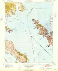 1948 San Quentin1948 Print · USGSThe North Bay waterfront comes alive in the late 1940s, showing the active ferry routes and military installations of the era. Genealogists and historians can trace the Richmond-San Rafael Ferry, the State Penitentiary, and the Tiburon Naval Net Depot.2 unique versions available
 - 1948 Map of San Francisco, 1951 Print
 1948 San Francisco1951 Print · USGSThe Bay Area in the late 1940s reveals a landscape defined by rapid post-war growth and a heavy military presence at the Golden Gate. Trace the development of early trans-bay infrastructure like the Oakland-Bay Bridge and historic coastal defense sites such as Fort Funston and Alcatraz Island.
 - 1949 Map of Santa Rosa
 1949 Santa Rosa1949 Print · USGSThe North Bay and Wine Country appear here in the late 1940s, when the Northwestern Pacific RR still dominated regional transit. Genealogists and historians can trace old coastal outposts like Anchor Bay Settlement and the early layout of Santa Rosa.2 unique versions available
 - 1950 Map of Mt. Tamalpais, 1954 Print
 1950 Mt. Tamalpais1954 Print · USGSMarin County's dramatic coastline and the approach to the Golden Gate are shown here in the mid-fifties. Genealogists and historians can trace the early boundaries of Mill Valley, the coastal outposts of Bolinas and Stinson Beach, and several coastal military sites.4 unique versions available
 - 1951 Map of Petaluma Point
 1951 Petaluma Point1951 Print · USGSSan Pablo Bay and the Marin shoreline are captured here in the early fifties, detailing the transition from tidal marsh to inland hills. Trace the path of the Northwestern Pacific railroad past Rose or explore the historic site at China Camp.2 unique versions available
 - 1954 Map of San Rafael, 1955 Print
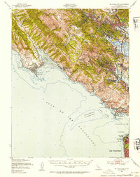
 1954 San Rafael1955 Print · USGSMid-century Marin County is captured here in detail, from the slopes of the redwood canyons to the bayside marshes. Genealogists and historians can trace the footprint of early schools like Alto School and Short School, or locate family sites near Mt Tamalpais Cemetery and Baltimore Park.7 unique versions available
 - 1954 Map of Novato, 1955 Print
 1954 Novato1955 Print · USGSMarin County's mid-century landscape is transitioning from a rural railroad corridor to a postwar suburban hub. Researchers can trace the layout of Hamilton Air Force Base, old schoolhouses like Dixie Sch, and the winding Northwestern Pacific line.6 unique versions available
 - 1954 Map of Petaluma, 1959 Print
 1954 Petaluma1959 Print · USGSCoastal mountains and river sloughs define the Marin and Sonoma borderlands in the mid-1950s, a period of military expansion and rural transition. Genealogists and historians can trace family-named schools like Iowa School or Wilson Sch and the extensive infrastructure of Hamilton Air Force Base.3 unique versions available
 - 1955 Map of San Francisco
 1955 San Francisco1955 Print · USGSThe San Francisco Bay Area and central coast are captured during the postwar boom as suburbs and infrastructure expanded rapidly. Trace the development of local communities and military installations like the Presidio and Fort Mason, or follow the Southern Pacific rail lines.
 - 1956 Map of San Francisco
 1956 San Francisco1956 Print · USGSThe San Francisco Bay Area is captured in the mid-fifties, showing a landscape of rapid post-war growth and massive military installations. Researchers can trace the sprawling rail lines of the Southern Pacific and locate historic sites like Stanford University or the Hunters Point Naval Shipyard.4 unique versions available
 - 1957 Map of San Francisco
 1957 San Francisco1957 Print · USGSThe Bay Area in the mid-fifties reveals a rapidly growing metropolitan landscape connected by its iconic spans and rail networks. Researchers can trace the layout of military sites like the Presidio and the extent of the Southern Pacific and Western Pacific railroads.
 - 1958 Map of Santa Rosa, 1968 Print
 1958 Santa Rosa1968 Print · USGSThe North Bay and Wine Country are captured in the mid-twentieth century as the region balanced its agricultural roots with a growing military and recreational footprint. Researchers can trace the Northwestern Pacific RR through the Russian River valley or locate landmarks like the Petaluma Adobe Historical Monument and The Geysers Resort.3 unique versions available
Showing maps 1-25 of 56
Top cities near San Rafael
- San Francisco historical maps
- Oakland historical maps
- Vallejo historical maps
- Berkeley historical maps
- Richmond historical maps
- Alameda historical maps
See more
Top neighborhoods of San Rafael
- Gallinas historical maps
- Cerro historical maps
- McNears Beach historical maps
- Terra Linda historical maps
- Las Gallinas historical maps
- Dominican historical maps
See more
Frequently asked questions
- What are the different types of historical maps available for San Rafael?
- What is the oldest map of San Rafael?
- Where can I purchase historical maps of San Rafael for my home or office?
- Where can I download high-res historical maps of San Rafael?
- Are there historical topographic maps available for San Rafael?
- Is there historical aerial imagery available for San Rafael?
- Where are historical maps of San Rafael sourced from?