1940s Maps of Midpines, California
Explore 5 historic maps of Midpines from the 1940s. These maps offer a rare glimpse into what life looked like during the 1940s — showing old roads, neighborhoods, homes, and landmarks that have changed or disappeared over time.
Whether you're researching your family's past, planning a metal detecting trip, or studying how Midpines's landscape evolved across the 1940s, these high-resolution maps are a powerful tool for exploring the history of this region.
- Focus on a specific era: All maps on this page are from the 1940s, giving you a focused view of this time period.
- See what’s changed: Compare century-old streets, trails, and buildings to today's modern landscape using overlays and satellite layers.
- Research with precision: Use these maps for genealogy, historical research, land use analysis, or educational projects.
- View, download, or print: Maps are fully viewable online in high resolution, and can be downloaded or printed for your own records.
Start exploring Midpines's history through authentic maps from the 1940s. This is your window into the past.
Midpines, CA maps
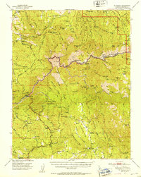
(5)- 1947 Map of Mariposa, 1948 Print
 1947 Mariposa1948 Print · USGSThe High Sierra and Owens Valley transition is captured here in the late 1940s, just as the region’s hydroelectric and tourism infrastructure was maturing. Genealogists and historians can trace old ranger stations, the Casa Diablo Mine, and rail stops along the Southern Pacific like Benton Station and Zurich.2 unique versions available
 - 1947 Map of El Portal, 1953 Print
 1947 El Portal1953 Print · USGSMariposa County in the late 1940s serves as the rugged threshold to Yosemite, defined by deep river canyons and early forest service outposts. Genealogists and historians can trace the foundations of mountain life at the Colorado Sch, Buffalo Mine, and the McCauley Ranch (Old Stage Sta).4 unique versions available
 - 1947 Map of Feliciana Mtn., 1965 Print
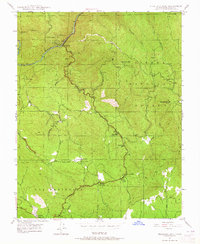 1947 Feliciana Mtn.1965 Print · USGSMariposa County during the post-war era shows a landscape defined by its mining heritage and the transition into a recreational gateway. You can trace old gold prospects like the King Solomon Mine or locate historic schoolhouses including Colorado Sch and Bear Creek Sch.3 unique versions available
 - 1948 Map of Feliciana Mtn.
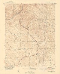 1948 Feliciana Mtn.1948 Print · USGSMariposa County in the late 1940s reveals a landscape of rugged gold mining claims and the early tourism of the Yosemite corridor. Genealogists and historians can trace the foundations of Midpines and Briceburg alongside remote landmarks like King Solomon Mine and the Colorado Sch.2 unique versions available
 - 1948 Map of Mariposa, 1951 Print
 1948 Mariposa1951 Print · USGSThe High Sierra and Mariposa foothills are shown here in the late 1940s as the post-war tourism and water infrastructure expanded. Genealogists and historians can locate vanished waypoints like Mormon Bar, the Glacier Point Hotel, and the granite quarries of Knowles.
End of results
Showing maps 1-5 of 5
Frequently asked questions
- What are the different types of historical maps available for Midpines?
- What is the oldest map of Midpines?
- Where can I purchase historical maps of Midpines for my home or office?
- Where can I download high-res historical maps of Midpines?
- Are there historical topographic maps available for Midpines?
- Is there historical aerial imagery available for Midpines?
- Where are historical maps of Midpines sourced from?