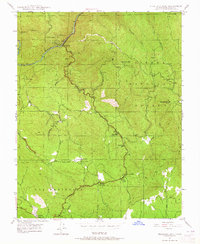
1947 Map of Feliciana Mtn.
USGS Topo · Published 1965About this map
The Merced River winds through the northwestern corner of this 1940s landscape, just as the Yosemite All-Year Highway (140) begins its climb through the Sierra foothills toward the national park. The map reveals a post-war mining and ranching economy, with numerous claims scattered across the high ridges, including the Schroeder Mine, Feliciana Mine, and Buffalo Mine. Settlement is concentrated along the highway corridor at places like Briceburg and Midpines, while the surrounding terrain is punctuated by local institutions such as the Colorado Sch and Bear Creek Sch. Much of the eastern portion is dominated by the Sierra National Forest, reaching its peak at Feliciana Mtn and Sweetwater Pt. The network of creeks—Sherlock Creek, Trabuco Creek, and Feliciana Creek—carve out the deep gulches that once drew prospectors to this rugged section of Las Mariposas.
Find a feature on this map
34 named features on this map. Tap any name to fly to it.
Don’t see what you’re looking for? This feature index may not catch every label — zoom into the map to look around manually.
Map Details
Editions of this 1947 Feliciana Mtn. Map
3 editions found
Other maps of this area

1893 · Sonora
USGS Topo · 1:125,000

1896 · Sonora
USGS Topo · 1:125,000

1897 · Sonora
USGS Topo · 1:125,000

1897 · Yosemite
USGS Topo · 1:125,000

1898 · Sonora
USGS Topo · 1:125,000

1900 · Yosemite
USGS Topo · 1:125,000

1903 · Yosemite
USGS Topo · 1:125,000

1909 · Yosemite
USGS Topo · 1:125,000

1912 · Mariposa
USGS Topo · 1:125,000

1919 · Indian Gulch
USGS Topo · 1:48,000