1990s Maps of North Wawona, California
Explore 2 historic maps of North Wawona from the 1990s. These maps offer a rare glimpse into what life looked like during the 1990s — showing old roads, neighborhoods, homes, and landmarks that have changed or disappeared over time.
Whether you're researching your family's past, planning a metal detecting trip, or studying how North Wawona's landscape evolved across the 1990s, these high-resolution maps are a powerful tool for exploring the history of this region.
- Focus on a specific era: All maps on this page are from the 1990s, giving you a focused view of this time period.
- See what’s changed: Compare century-old streets, trails, and buildings to today's modern landscape using overlays and satellite layers.
- Research with precision: Use these maps for genealogy, historical research, land use analysis, or educational projects.
- View, download, or print: Maps are fully viewable online in high resolution, and can be downloaded or printed for your own records.
Start exploring North Wawona's history through authentic maps from the 1990s. This is your window into the past.
North Wawona, CA maps
(2)- 1990 Map of Wawona
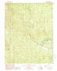 1990 Wawona1990 Print · USGSWawona and the southern reaches of Yosemite are captured in the late 1980s, documenting the intersection of protected wilderness and local community. Genealogists and historians can locate the Wawona School, the landmark Covered Bridge, and various campsites along the South Fork Merced River.
 - 1992 Map of Wawona, 1995 Print
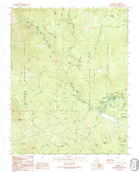 1992 Wawona1995 Print · USGSYosemite's southern gateway comes into focus in the early nineties, centered on the historic mountain community of Wawona. Researchers can trace local infrastructure from the Wawona Sch and Covered Bridge to the remote sites of Stovepipe Campground and Summit Campground.
End of results
Showing maps 1-2 of 2
Top cities near North Wawona
Frequently asked questions
- What are the different types of historical maps available for North Wawona?
- What is the oldest map of North Wawona?
- Where can I purchase historical maps of North Wawona for my home or office?
- Where can I download high-res historical maps of North Wawona?
- Are there historical topographic maps available for North Wawona?
- Is there historical aerial imagery available for North Wawona?
- Where are historical maps of North Wawona sourced from?