1940s Maps of Boonville, California
Explore 5 historic maps of Boonville from the 1940s. These maps offer a rare glimpse into what life looked like during the 1940s — showing old roads, neighborhoods, homes, and landmarks that have changed or disappeared over time.
Whether you're researching your family's past, planning a metal detecting trip, or studying how Boonville's landscape evolved across the 1940s, these high-resolution maps are a powerful tool for exploring the history of this region.
- Focus on a specific era: All maps on this page are from the 1940s, giving you a focused view of this time period.
- See what’s changed: Compare century-old streets, trails, and buildings to today's modern landscape using overlays and satellite layers.
- Research with precision: Use these maps for genealogy, historical research, land use analysis, or educational projects.
- View, download, or print: Maps are fully viewable online in high resolution, and can be downloaded or printed for your own records.
Start exploring Boonville's history through authentic maps from the 1940s. This is your window into the past.
Boonville, CA maps
(5)- 1943 Map of Boonville, 1954 Print
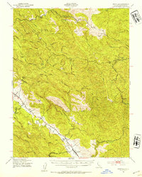 1943 Boonville1954 Print · USGSMendocino County's ranching and timber heartland is captured here during the 1940s, focused on the Anderson Valley settlements. Genealogists and researchers can trace family-named sites like Whipple Ranch and Hagemann Ranch, along with several rural schoolhouses such as Con Creek Sch.
 - 1943 Map of Ornbaun, 1961 Print
 1943 Ornbaun1961 Print · USGSNorthern California ranching and early resort history are documented here in the early 1940s along the Mendocino-Sonoma border. Genealogists can trace family holdings like Zeni Ranch and Rickard Ranch or locate the site of the Old Ornbaun Hot Springs.
 - 1944 Map of Ornbaun
 1944 Ornbaun1944 Print · USGSCoastal range ranching and timber lands are documented here in the mid-1940s at the Mendocino and Sonoma border. Researchers can trace historic family holdings like the Ornbaun Ranch, the Old Red Rock Place, and the remote Helvetian Gun Club.
 - 1947 Map of Santa Rosa
 1947 Santa Rosa1947 Print · USGSNorthern California in the late 1940s was a landscape of agricultural valleys and vital rail hubs. Trace the historic routes of the Northwestern Pacific through Healdsburg or explore the mid-century waterfronts of Vallejo and Benicia near Mare Island.
 - 1949 Map of Santa Rosa
 1949 Santa Rosa1949 Print · USGSThe North Bay and Wine Country appear here in the late 1940s, when the Northwestern Pacific RR still dominated regional transit. Genealogists and historians can trace old coastal outposts like Anchor Bay Settlement and the early layout of Santa Rosa.2 unique versions available
End of results
Showing maps 1-5 of 5
Top cities near Boonville
Frequently asked questions
- What are the different types of historical maps available for Boonville?
- What is the oldest map of Boonville?
- Where can I purchase historical maps of Boonville for my home or office?
- Where can I download high-res historical maps of Boonville?
- Are there historical topographic maps available for Boonville?
- Is there historical aerial imagery available for Boonville?
- Where are historical maps of Boonville sourced from?