1990s Maps of Boonville, California
Explore 3 historic maps of Boonville from the 1990s. These maps offer a rare glimpse into what life looked like during the 1990s — showing old roads, neighborhoods, homes, and landmarks that have changed or disappeared over time.
Whether you're researching your family's past, planning a metal detecting trip, or studying how Boonville's landscape evolved across the 1990s, these high-resolution maps are a powerful tool for exploring the history of this region.
- Focus on a specific era: All maps on this page are from the 1990s, giving you a focused view of this time period.
- See what’s changed: Compare century-old streets, trails, and buildings to today's modern landscape using overlays and satellite layers.
- Research with precision: Use these maps for genealogy, historical research, land use analysis, or educational projects.
- View, download, or print: Maps are fully viewable online in high resolution, and can be downloaded or printed for your own records.
Start exploring Boonville's history through authentic maps from the 1990s. This is your window into the past.
Boonville, CA maps
(3)- 1991 Map of Boonville
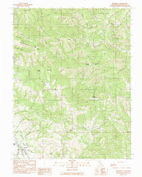 1991 Boonville1991 Print · USGSBoonville and the southern reaches of the Anderson Valley are documented here in the early nineties, showing a landscape of deep canyons and family-named ridges. Genealogists and researchers can trace local landmarks like Fairground, Soda Spring, and Casabonne Peak.
 - 1991 Map of Ornbaun Valley
 1991 Ornbaun Valley1991 Print · USGSMendocino County’s rugged interior is captured here in the early nineties, showing a landscape shaped by deep timber reserves and ranching history. Researchers can locate the Ornbaun Cem, the protected groves of Mailliard Redwoods State Reserve, and the waters of the Garcia River.
 - 1991 Map of Philo
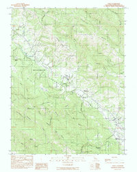 1991 Philo1991 Print · USGSMendocino County's Anderson Valley is documented in the early nineties, showing a landscape defined by the Navarro River and local timber history. Genealogists can trace family landmarks like Hagemann Ranch, Shields Cem, and Philbrick Mill.
End of results
Showing maps 1-3 of 3
Top cities near Boonville
Frequently asked questions
- What are the different types of historical maps available for Boonville?
- What is the oldest map of Boonville?
- Where can I purchase historical maps of Boonville for my home or office?
- Where can I download high-res historical maps of Boonville?
- Are there historical topographic maps available for Boonville?
- Is there historical aerial imagery available for Boonville?
- Where are historical maps of Boonville sourced from?