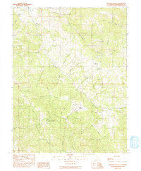
1991 Map of Ornbaun Valley
USGS Topo · Published 1991About this map
Mailliard Redwoods State Reserve anchors the southwestern portion of this Mendocino County landscape, protecting a significant stand of redwood forest near the headwaters of the Garcia River. The geography is defined by a dense network of watercourses, most notably Rancheria Creek and its numerous tributaries like Shearing Creek and Beasley Creek, which cut through the high ridges of the Coast Range. The settlement of Ornbaun Valley serves as a small focal point in the central hills, accompanied by the Ornbaun Cem and nearby Ornbaun Sprs. This 1991 provisional survey, based on data reaching back to the late 1950s, documents the region's long-standing character as a timber and ranching frontier. Signs of resource management and rural infrastructure are evident in the State Forest Fire Sta and the Gravel Pit located near the northern border along Anderson Creek.
Find a feature on this map
35 named features on this map. Tap any name to fly to it.
Don’t see what you’re looking for? This feature index may not catch every label — zoom into the map to look around manually.
Map Details
Editions of this 1991 Ornbaun Valley Map
This is the sole edition of this map. No revisions or reprints were ever made.
Other maps of this area

1920 · Ukiah
USGS Topo · 1:62,500

1938 · Hopland
USGS Topo · 1:62,500

1943 · Boonville
USGS Topo · 1:62,500

1943 · Hopland
USGS Topo · 1:62,500

1943 · Ornbaun
USGS Topo · 1:62,500

1944 · Ukiah
USGS Topo · 1:62,500

1944 · Ornbaun
USGS Topo · 1:62,500

1944 · Hopland
USGS Topo · 1:62,500

1947 · Santa Rosa
USGS Topo · 1:250,000

1949 · Santa Rosa
USGS Topo · 1:250,000