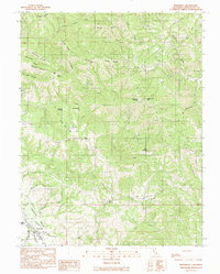
1991 Map of Boonville
USGS Topo · Published 1991About this map
Boonville sits at the southwestern edge of this 1991 provisional survey, serving as the gateway to the fertile Anderson Valley. The map detail captures the town's early 1990s layout, including the local Fairground and the confluence of Mill Creek and Robinson Creek. North of the settlement, the landscape transitions into a series of ridges and named clearings that hint at the region's agricultural and ranching history.
Find a feature on this map
42 named features on this map. Tap any name to fly to it.
Don’t see what you’re looking for? This feature index may not catch every label — zoom into the map to look around manually.
Map Details
Editions of this 1991 Boonville Map
This is the sole edition of this map. No revisions or reprints were ever made.
Other maps of this area

1920 · Ukiah
USGS Topo · 1:62,500

1938 · Hopland
USGS Topo · 1:62,500

1943 · Boonville
USGS Topo · 1:62,500

1943 · Hopland
USGS Topo · 1:62,500

1943 · Ornbaun
USGS Topo · 1:62,500

1944 · Ukiah
USGS Topo · 1:62,500

1944 · Ornbaun
USGS Topo · 1:62,500

1944 · Hopland
USGS Topo · 1:62,500

1947 · Santa Rosa
USGS Topo · 1:250,000

1949 · Santa Rosa
USGS Topo · 1:250,000