1910s Maps of Gustine, California
Explore 4 historic maps of Gustine from the 1910s. These maps offer a rare glimpse into what life looked like during the 1910s — showing old roads, neighborhoods, homes, and landmarks that have changed or disappeared over time.
Whether you're researching your family's past, planning a metal detecting trip, or studying how Gustine's landscape evolved across the 1910s, these high-resolution maps are a powerful tool for exploring the history of this region.
- Focus on a specific era: All maps on this page are from the 1910s, giving you a focused view of this time period.
- See what’s changed: Compare century-old streets, trails, and buildings to today's modern landscape using overlays and satellite layers.
- Research with precision: Use these maps for genealogy, historical research, land use analysis, or educational projects.
- View, download, or print: Maps are fully viewable online in high resolution, and can be downloaded or printed for your own records.
Start exploring Gustine's history through authentic maps from the 1910s. This is your window into the past.
Gustine, CA maps
(4)- 1917 Map of Newman
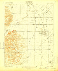 1917 Newman1917 Print · USGSNewman and the surrounding San Joaquin Valley are captured here during a period of rapid agricultural expansion before the First World War. Researchers can trace the early irrigation grid and find local landmarks like Orestimba School, the Cem, and the rail lines serving Gustine.3 unique versions available
 - 1918 Map of Gustine
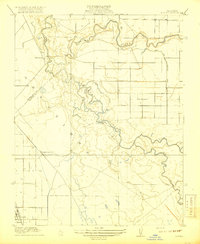 1918 Gustine1918 Print · USGSThe San Joaquin and Merced Rivers meet during the era of early irrigation development in the valley. Genealogists and local historians can trace the early layout of Gustine, find the location of Hills Ferry, and locate the historic Fremont Ford crossing.2 unique versions available
 - 1919 Map of Orestimba
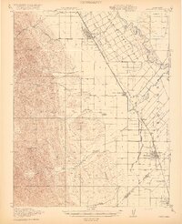 1919 Orestimba1919 Print · USGSThe western San Joaquin Valley comes alive in the years following the Great War, showing a landscape defined by the growth of irrigation and rail. Genealogists and historians can locate early homesteads near Patterson, rural schoolhouses like Canal School, and the extensive MAIN CANAL system.3 unique versions available
 - 1919 Map of Ingomar
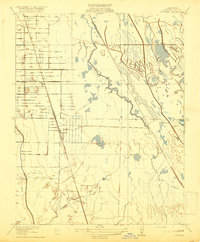 1919 Ingomar1919 Print · USGSMerced County at the height of the valley's agricultural expansion reveals a landscape of irrigation canals and rail-side hamlets. Trace the early layout of Ingomar, the Eagle Ranch, and the path of the Old Santa Fe Grade.2 unique versions available
End of results
Showing maps 1-4 of 4
Top cities near Gustine
- Turlock historical maps
- Los Banos historical maps
- Patterson historical maps
- Delhi historical maps
- Newman historical maps
Frequently asked questions
- What are the different types of historical maps available for Gustine?
- What is the oldest map of Gustine?
- Where can I purchase historical maps of Gustine for my home or office?
- Where can I download high-res historical maps of Gustine?
- Are there historical topographic maps available for Gustine?
- Is there historical aerial imagery available for Gustine?
- Where are historical maps of Gustine sourced from?