
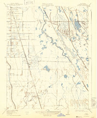
1919 Map of Ingomar
USGS Topo · Published 1919About this map
The Southern Pacific railroad corridor defines the development of this Central Valley landscape during the early twentieth century, serving as the primary anchor for small rail-side settlements like Ingomar and Linora. This 1:31,680 scale survey illustrates a transition from organized agricultural plots in the west to the natural drainage patterns of the east, where Garzas Creek and Mud Slough meander toward the San Joaquin basin. The map documents an important era in Merced County water management, showing an extensive network of irrigation canals and ditches that contrast sharply with the untamed flows of San Luis Creek and Los Banos Creek. For the historian, the inclusion of the Old Santa Fe Grade provides a clear view of earlier transportation routes that once paralleled the more modern steel rails.
Find a feature on this map
9 named features on this map. Tap any name to fly to it.
Don’t see what you’re looking for? This feature index may not catch every label — zoom into the map to look around manually.
Map Details
Editions of this 1919 Ingomar Map
2 editions found
Other maps of this area

1917 · Newman
USGS Topo · 1:31,680

1918 · Stevinson
USGS Topo · 1:31,680

1918 · Gustine
USGS Topo · 1:31,680

1919 · Orestimba
USGS Topo · 1:62,500

1919 · San Luis Ranch
USGS Topo · 1:31,680

1920 · Pacheco Pass
USGS Topo · 1:62,500

1921 · Volta
USGS Topo · 1:31,680

1921 · Los Banos
USGS Topo · 1:31,680

1922 · San Luis Creek
USGS Topo · 1:31,680

1922 · Howard Ranch
USGS Topo · 1:31,680