Old Maps of Gustine, California for Genealogy
Trace your family roots with 40 historic maps of Gustine. These high-res maps reveal old neighborhoods, homesites, landmarks, and streets — helping you uncover where your ancestors lived and how the area evolved over time.
- Explore historic neighborhoods: Identify where your relatives may have lived in the 1800s or 1900s.
- Compare maps over time: Trace the changes in streets, buildings, and landmarks for multi-generational research.
- Perfect for genealogy & ancestry research: Used by family historians and researchers to map out lineage and migration.
These maps are an incredible resource for exploring your personal connection to Gustine's past.
Gustine, CA maps
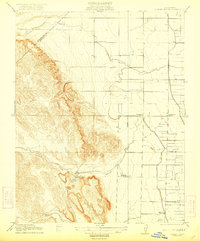
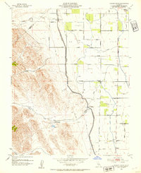
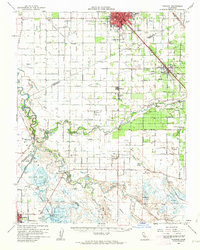
(40)- 1917 Map of Newman
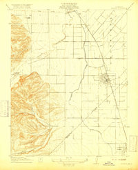 1917 Newman1917 Print · USGSNewman and the surrounding San Joaquin Valley are captured here during a period of rapid agricultural expansion before the First World War. Researchers can trace the early irrigation grid and find local landmarks like Orestimba School, the Cem, and the rail lines serving Gustine.3 unique versions available
 - 1918 Map of Gustine
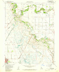
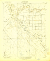 1918 Gustine1918 Print · USGSThe San Joaquin and Merced Rivers meet during the era of early irrigation development in the valley. Genealogists and local historians can trace the early layout of Gustine, find the location of Hills Ferry, and locate the historic Fremont Ford crossing.2 unique versions available
 - 1919 Map of Orestimba
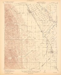 1919 Orestimba1919 Print · USGSThe western San Joaquin Valley comes alive in the years following the Great War, showing a landscape defined by the growth of irrigation and rail. Genealogists and historians can locate early homesteads near Patterson, rural schoolhouses like Canal School, and the extensive MAIN CANAL system.3 unique versions available
 - 1919 Map of Ingomar
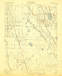 1919 Ingomar1919 Print · USGSMerced County at the height of the valley's agricultural expansion reveals a landscape of irrigation canals and rail-side hamlets. Trace the early layout of Ingomar, the Eagle Ranch, and the path of the Old Santa Fe Grade.2 unique versions available
 - 1920 Map of Pacheco Pass
 1920 Pacheco Pass1920 Print · USGSThe Pacheco Pass gateway and the eastern Diablo Range are captured here during the early twentieth century. Researchers can trace historic local life through sites like the Bald Eagle Mine, San Luis Ranch, and Cottonwood School.4 unique versions available
 - 1922 Map of Howard Ranch
 1922 Howard Ranch1922 Print · USGSThe foothills of the Diablo Range meet the San Joaquin Valley in this early twentieth-century survey. Genealogists and historians can trace rural family life through the locations of the Occidental School, Cottonwood Church, and the historic Howard Ranch.2 unique versions available
 - 1940 Map of Pacheco Pass
 1940 Pacheco Pass1940 Print · USGSPacheco Pass and the surrounding Merced County foothills are captured here in the years leading up to the war. Genealogists can locate family holdings like Howard Ranch and Fifield Ranch, or trace rural education at Romero School.
 - 1941 Map of Orestimba
 1941 Orestimba1941 Print · USGSThe San Joaquin Valley and Diablo Range foothills meet here in the early 1940s, showing a landscape defined by industrial irrigation and rail. Trace the Southern Pacific line through Patterson and Newman, or locate rural landmarks like the Canal School and Stimba Pumping Station.
 - 1942 Map of Irwin
 1942 Irwin1942 Print · USGSThe San Joaquin and Merced rivers dominate this 1940s landscape where early irrigation networks met established rail lines. Genealogists can trace rural school districts like Tegner Sch and Helmar Sch or locate old river crossings at Hills Ferry and Fremont Ford.
 - 1947 Map of Gustine
 1947 Gustine1947 Print · USGSThe northern San Joaquin Valley comes into focus just after the war as the agricultural and irrigation networks expand around the So Pacific tracks. Genealogists can trace family footprints at Hills Ferry, Bella Vista Park, and the Stevinson Home-Ranch.
 - 1947 Map of Ingomar
 1947 Ingomar1947 Print · USGSThe northern San Joaquin Valley in the late 1940s is shown here as a landscape of railroads and irrigation. Genealogists and researchers can trace the agricultural heart of Merced County through the Southern Pacific line, the Ingomar Ranch, and the Linora Pumping Station.
 - 1947 Map of San Jose, 1948 Print
 1947 San Jose1948 Print · USGSNorthern California's heartland is captured here just after the war, showing the rapid growth of the Santa Clara and Central Valleys. Researchers can trace the legacy of rail and water at Castle Air Force Base, Stockton, and the Hetch Hetchy Aqueduct.
 - 1952 Map of Newman, 1954 Print
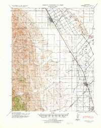
 1952 Newman1954 Print · USGSThe San Joaquin Valley's agricultural landscape is captured here in the early 1950s, showing the critical rail and water systems that drove the region. Genealogists can trace family holdings along Stuhr Road or locate landmarks like the Canal Sch and West Side Hosp.4 unique versions available
 - 1953 Map of Howard Ranch, 1954 Print
 1953 Howard Ranch1954 Print · USGSThe Central Valley meets the foothills in the 1950s as the Delta-Mendota Canal transforms the Merced and Stanislaus landscape. Researchers can trace rural life via Howard Ranch, Cottonwood School, and the family-named grid of Taglio Road.4 unique versions available
 - 1956 Map of San Jose
 1956 San Jose1956 Print · USGSCentral California in the mid-fifties reveals the transition from sprawling orchards to growing urban hubs like San Jose and Stockton. Genealogists and historians can trace the rail-era landscape of the Mother Lode through Chinese Camp and Tuttletown, or follow the water through the Joaquin River and Calaveras Reservoir.
 - 1960 Map of Gustine, 1961 Print
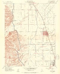
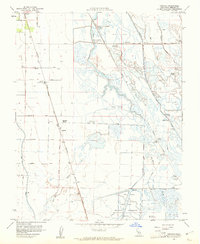
 1960 Gustine1961 Print · USGSThe northern San Joaquin Valley is shown here at the start of the 1960s, shaped by the meeting of the Merced and San Joaquin Rivers. Genealogists and historians can trace the Stevinson Home Ranch, the grounds of Stevinson Sunnyside Cem, and the path of the Old Santa Fe Grade.3 unique versions available
 - 1960 Map of Ingomar, 1961 Print
 1960 Ingomar1961 Print · USGSMerced County marshlands and ranching tracts are captured here in the early sixties, showing a landscape defined by water management and the Southern Pacific rail line. Genealogists and local historians can locate Ingomar, trace family-named roads like Kniebes Road, and explore dozens of legacy hunting sites including the Gustine Gun Club.2 unique versions available
 - 1961 Map of Los Banos, 1963 Print
 1961 Los Banos1963 Print · USGSMerced County in the early 1960s reveals an engineered agricultural landscape of extensive canal systems and railroad-aligned towns. Genealogists and local researchers can trace family landmarks like Odd Fellows Grove, the local Cem, and the busy hub of Los Banos.
 - 1962 Map of San Jose
 1962 San Jose1962 Print · USGSCentral California in the early sixties showcases the expansion of the San Joaquin and Santa Clara valleys. Researchers can trace the rail-to-road transition along the Southern Pacific RR or locate landmarks like Castle USAF Base and Loma Prieta.4 unique versions available
 - 1962 Map of Turlock, 1963 Print
 1962 Turlock1963 Print · USGSThe San Joaquin Valley's agricultural heartland is documented here during the early sixties. Trace historical landmarks like the Hilmar High Sch, find family plots at Stevinson Sunnyside Cem, and follow the Southern Pacific rail line.2 unique versions available
 - 1966 Map of San Jose
 1966 San Jose1966 Print · USGSCentral California in the mid-1960s reveals a landscape of massive irrigation projects and expanding Cold War military footprints. Researchers can trace the rail-and-river network of the San Joaquin Valley or locate specialized sites like Castle Air Force Base and the Sharp General Depot (Military).
 - 1978 Map of San Jose
 1978 San Jose1978 Print · USGSSanta Clara County and the East Bay hills are captured in the late seventies, showing the suburban sprawl of San Jose alongside the rural Central Valley. Trace the paths of the Southern Pacific railroad and find landmarks like New Almaden and Lick Observatory.
 - 1983 Map of Merced
 1983 Merced1983 Print · USGSThe San Joaquin Valley at the start of the eighties is captured here in its full agricultural and military height. Trace the legacy of Castle Air Force Base, old mines like Pocahontas Mine, and the vast Kesterson National Wildlife Refuge.
 - 1999 Map of Howard Ranch, 2002 Print
 1999 Howard Ranch2002 Print · USGSWestern Merced County comes into sharp focus during the late twentieth century as irrigation canals reshaped the valley landscape. Trace local family roots and land use through Howard Ranch, Cottonwood School, and Garzas Creek.
 - 2012 Map of Gustine, 2012 Print
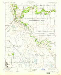
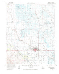
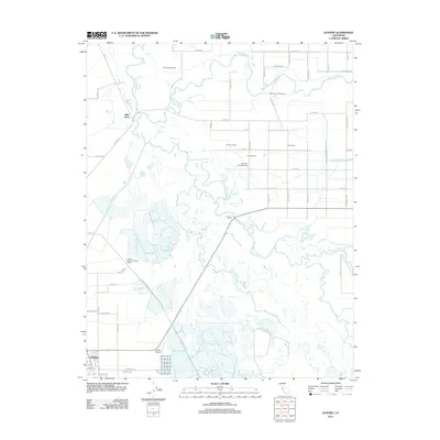 2012 Gustine2012 Print · USGSCovers Gustine, including Hills Ferry, Stanislaus County, and other nearby areas
Showing maps 1-25 of 40
Top cities near Gustine
- Turlock historical maps
- Los Banos historical maps
- Patterson historical maps
- Delhi historical maps
- Newman historical maps
Frequently asked questions
- What are the different types of historical maps available for Gustine?
- What is the oldest map of Gustine?
- Where can I purchase historical maps of Gustine for my home or office?
- Where can I download high-res historical maps of Gustine?
- Are there historical topographic maps available for Gustine?
- Is there historical aerial imagery available for Gustine?
- Where are historical maps of Gustine sourced from?