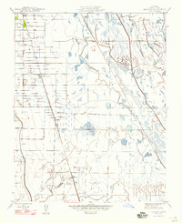
1947 Map of Ingomar
USGS Topo · Published 1947About this map
Agricultural development and water management define this Central Valley landscape during the mid-1940s. The Southern Pacific railroad corridor serves as the primary spine for settlement, connecting the established community of Gustine to the smaller siding at Ingomar and the nearby Ingomar Ranch. This era represents a period of significant hydraulic engineering, evidenced by the large-scale San Luis Canal and Santa Fe Canal that redirect water across the arid plains. Natural drainages like Garzas Creek, Los Banos Creek, and Mud Slough intersect a grid of irrigation ditches and wells, supporting a landscape of intensive farming and ranching. Infrastructure for water and recreation is also visible, including the Linora Pumping Station and the Gustine Gun Club, illustrating how the land was organized for both production and sport.
Find a feature on this map
17 named features on this map. Tap any name to fly to it.
Don’t see what you’re looking for? This feature index may not catch every label — zoom into the map to look around manually.
Map Details
Editions of this 1947 Ingomar Map
This is the sole edition of this map. No revisions or reprints were ever made.
Other maps of this area

1917 · Newman
USGS Topo · 1:31,680

1918 · Stevinson
USGS Topo · 1:31,680

1918 · Gustine
USGS Topo · 1:31,680

1919 · Orestimba
USGS Topo · 1:62,500

1919 · San Luis Ranch
USGS Topo · 1:31,680

1919 · Ingomar
USGS Topo · 1:31,680

1920 · Pacheco Pass
USGS Topo · 1:62,500

1921 · Volta
USGS Topo · 1:31,680

1921 · Los Banos
USGS Topo · 1:31,680

1922 · San Luis Creek
USGS Topo · 1:31,680