
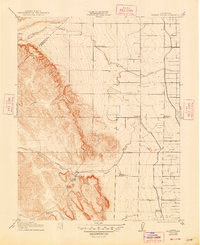
1922 Map of Howard Ranch
USGS Topo · Published 1922About this map
Howard Ranch and the surrounding rangeland sit at the edge of the Central Valley where the foothills of the Coast Ranges begin to rise. Surveyed during a period of transition in California agriculture and infrastructure, this map details the vital role of seasonal watercourses like Garzas Creek and Mustang Creek in shaping the early ranching landscape. The presence of the Shell Pumping Sta indicates the early 20th-century expansion of oil infrastructure through this rural corridor.
Find a feature on this map
12 named features on this map. Tap any name to fly to it.
Don’t see what you’re looking for? This feature index may not catch every label — zoom into the map to look around manually.
Map Details
Editions of this 1922 Howard Ranch Map
2 editions found
Other maps of this area

1917 · Newman
USGS Topo · 1:31,680

1918 · Gustine
USGS Topo · 1:31,680

1919 · Orestimba
USGS Topo · 1:62,500

1919 · Orestimba Creek
USGS Topo · 1:31,680

1919 · Ingomar
USGS Topo · 1:31,680

1920 · Pacheco Pass
USGS Topo · 1:62,500

1921 · Volta
USGS Topo · 1:31,680

1922 · San Luis Creek
USGS Topo · 1:31,680

1940 · Pacheco Pass
USGS Topo · 1:62,500

1941 · Orestimba
USGS Topo · 1:62,500