1990s Maps of Day, California
Explore 2 historic maps of Day from the 1990s. These maps offer a rare glimpse into what life looked like during the 1990s — showing old roads, neighborhoods, homes, and landmarks that have changed or disappeared over time.
Whether you're researching your family's past, planning a metal detecting trip, or studying how Day's landscape evolved across the 1990s, these high-resolution maps are a powerful tool for exploring the history of this region.
- Focus on a specific era: All maps on this page are from the 1990s, giving you a focused view of this time period.
- See what’s changed: Compare century-old streets, trails, and buildings to today's modern landscape using overlays and satellite layers.
- Research with precision: Use these maps for genealogy, historical research, land use analysis, or educational projects.
- View, download, or print: Maps are fully viewable online in high resolution, and can be downloaded or printed for your own records.
Start exploring Day's history through authentic maps from the 1990s. This is your window into the past.
Day, CA maps
(2)- 1990 Map of Day
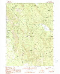 1990 Day1990 Print · USGSUpper Modoc and Shasta counties appear as a rugged landscape of volcanic peaks and forest basins during the 1990s. Researchers can trace the Old Railroad Grade, locate the isolated settlement of Day with its cemetery, and identify the Widow Mountain Radio Facility.
 - 1995 Map of Day, 1997 Print
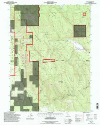 1995 Day1997 Print · USGSThe Modoc high country comes into focus in the mid-nineties, showing the rural settlement of Day and the tri-county borders of Shasta, Lassen, and Modoc. Researchers can trace the path of the Old R.R. Grade or locate family landmarks like Brown Cabin and the local Cem.
End of results
Showing maps 1-2 of 2
Frequently asked questions
- What are the different types of historical maps available for Day?
- What is the oldest map of Day?
- Where can I purchase historical maps of Day for my home or office?
- Where can I download high-res historical maps of Day?
- Are there historical topographic maps available for Day?
- Is there historical aerial imagery available for Day?
- Where are historical maps of Day sourced from?